
Drones in the sky! Aerial surveys to shape future flood defences in north Louth


Drones to map flood-prone areas as part of major flood relief project
Residents in Carlingford, Greenore, and surrounding areas may soon notice drones in the skies as a major aerial survey project gets underway to assess future flood defence needs.
Louth County Council has engaged a geospatial contractor to carry out topographic aerial surveys as part of the Carlingford and Greenore Flood Relief Scheme. These surveys, set to begin on Wednesday, February 19, 2025, will use drone technology to map the topography of the region.
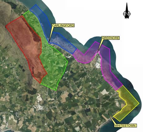
The data gathered will play a crucial role in flood modelling and could help shape future flood protection measures for the area. The survey zone includes Carlingford Town, Greenore, Commons, and the entire coastline from north Carlingford to Whitestown.
The surveys will be non-intrusive, meaning no access to private property or lands is required. Drone flights will take place over several weeks, subject to weather and tide conditions. The geospatial contractor conducting the work will carry official identification.
Survey Schedule
The planned schedule for the surveys is as follows:
- Day 1 (Feb 19): Green and blue coastline, lower hills, and the area around Carlingford.
- Day 2: Green lower hills and area around Carlingford.
- Day 3: Red and purple high ground around Carlingford and coastline from Greenore to Ballagan.
- Day 4: Red and yellow high ground around Carlingford and coastline from Ballagan to Whitestown Beach.
- Day 5: Any remaining areas, with a contingency day to complete unfinished flights.
Locals with any questions or concerns regarding the survey can contact the Carlingford and Greenore Flood Relief Scheme Project Team at [email protected] or by calling 042 93 35457.