
Hill Street Views: A Boyne pillbox and an alternative Louth history


Columnist David Lynch writes about World War 2 pillboxes and an alternative Louth history
So, I was chatting to a man at the bottom of his garden in Meath a little while back during that wonderful summer we had.
We batted the breeze for a bit – weather, the auld rivalry, ‘do you know such-and-such from Dunleer?’ As the conversation drifted, he pointed towards a drop beyond the fence at the end of the lawn adjacent to the main road and said there was a World War 2 pillbox hidden in there.
I looked a little closer and sure enough there was a flat concrete bunker-like roof just about visible beneath the overgrown hedge engulfing it.
It would most likely have been manned by the LDF (Local Defence Force) during the Emergency - as the global conflagration was called here in Eire - and was one of many built along the River Boyne.
The pillboxes were built as a fortification line running all the way from Navan eventually ending at the mouth of the Boyne near Drogheda. Their purpose? To stall any potential enemy invasion.
Who was more likely to invade Ireland during World War 2?
To this day there are still competing schools of thought as to who the Irish Free State truly believed might end up invading the country – Hitler or Churchill.
It is well-known that Nazi Germany had drawn up a plan to invade Ireland which was codenamed Operation Green. While the details of this preliminary plan may have been unknown to the British, London knew that an invasion of Ireland by Hitler and its use as a staging post for launching an invasion on Britain was a clear and present danger.
Whether it was a German or British attack (or even a unconnected combination of both) perhaps hedging their bets and preparing for both potential outcomes was the sensible play for the Irish Free State.
In the event of an uncalled-for British invasion, in the Irish government’s mind, the likes of Louth, Monaghan and Cavan would be lost quickly and therefore the Boyne would be the most robust geographical barrier best suited to prevent them venturing further south.
Sensible in theory but the reality of any such invasion materialising would have shown the inherent weakness of this ‘Irish Maginot Line’ (as our man in his garden glibly remarked).
With the LDF manning these posts armed with bolt-action Lee-Enfield rifles and a handful of ammunition, coupled with the pillboxes’ light-weight construction, it wouldn’t have taken the British army long to put them out of action or simply steamroll past them.
However, at least the Irish Government was willing to make a token attempt at a last stand to save Meath. The Wee County was written off early doors, unfortunately.
Location of pillboxes today
A surprising number of these pillboxes are still visible today. Most notably near Oldbridge and the Battle of the Boyne site. While more fortifications remain intact near Mell in Drogheda and Mornington.
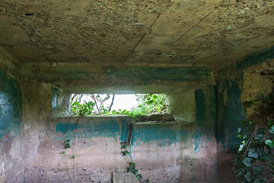
A similar line of fortifications was built along the Shannon estuary and in total over 300 were hastily erected at key strategic locations across the country, ranging from the aforementioned Boyne Valley on the east coast, to Limerick in the west and also around the Irish Army HQ at the Curragh in County Kildare.
If the alternative history which prompted the Irish Government to put these fortifications in place had played out, and the British had invaded, what would have happened in Louth?
Well, if we are to war game that scenario, it’s likely the British would have moved across the land border into the Free State with relative ease while also possibly attempting an amphibious landing somewhere along the east coast (most likely around Drogheda).
Both these invading armies would then advance and eventually meet up to form a larger combined force before marching south.
What is factually known is that as part of a preliminary military operation, Winston Churchill asked for a plan to be drawn up – with Major General Bernard ‘Monty’ Mongomery as lead - to retake Ireland’s Treaty Ports at Cobh and Berehaven in Cork and Lough Swilly in Donegal.
While this operation was significant it was limited in scope – it would not have been an outright ‘invasion’ of the Irish Free State. Plan W, however, was something altogether more audacious in scale.
What was Plan W?
Dublin and London maintained excellent communications in the early years of the war. Germany was marching almost unopposed across Western Europe, so plans for Britain to help repel a possible Nazi invasion of Ireland (with the cooperation of the Irish government) started to firm up. But a lack of trust was never far away as either side reserved niggling doubts about the other’s true intentions.
As part of Plan W (which was the proposed joint response from both governments) Dundalk was explicitly mentioned as one of three principal routes along which British troops were to advance south towards Dublin if Germany invaded Ireland and the Irish state asked for assistance from across the Irish sea.
The British 53rd Infantry Division was pencilled in for this operation (later bolstered by the 5th Battalion, Chesire Regiment).
The other two routes looked at were further inland through Ardee and Slane and then also through Monaghan via Castleblayney, Carrickmacross and then Navan.
Of course, this ‘invasion’ by British forces would have been at the behest of the Irish State and planned with its direct assistance and oversight. However, when boots hit the ground in any military conflict who has overall operational control becomes much more difficult to discern and, over time, this likely would have been a serious point of contention between the Irish and British authorities.
How would locals in Dundalk have felt as British troops marched down Clanbrassil Street and Park Street in 1940?
It would have taken some extraordinary and astute Irish Government messaging and political spinning to allay public fears and prevent any bad actors from conspiring to inflict losses on the British forces via a guerilla campaign.
Plan W also included detailed logistics and transport preparations.
This included using the main Belfast to Dublin rail line to move large amounts of war materiel and provisions for the British army down south to repel a German advance. Dundalk’s Clarke Station would likely have become a major hub for onward-travelling British forces and equipment.
Further Irish response to invasion threat
With the escalation of the war throughout 1940, the Irish Army responded by drawing up contingency plans at the border beyond the construction of pillboxes.
These first line of defence plans could be used in the event of either a Nazi attack or an unsolicited invasion from British forces.
Key river bridging points in County Louth were understood to have been earmarked for rigging with explosives to hamper enemy movements.
There was one exception, though. Plan W explicitly called for the British 1st Heavy Anti-Aircraft Regiment to take up position in Drogheda to prevent German air attack on the vital Boyne Viaduct along the Belfast to Dublin corridor.
By late 1940 and Nazi Germany’s failure in the Battle of Britain coupled with Hitler’s subsequent advance on Russia, the threat of invasion had diminished somewhat and by 1943 the real possibility of invasion was no longer a top priority for either Ireland or Britain.
Yet, the remnants of what-could-have-been remain dotted across the landscape to this day. Hidden in plain sight.