
ALERT: Met Éireann's Irish weather forecast for the weekend and next few days is in...

At last, we might have a bit of a summer!
Thursday: There'll be a good lot of cloud around for a time, with a little rain and drizzle and some mist in places.
However, it'll become brighter from the west later in the morning and through the afternoon, with good spells of sunshine developing.
Scattered showers will develop too through the afternoon and evening, and some will be heavy, especially across Ulster, North Connacht and the North Midlands.
Highs of 16 to 20 or 21 degrees in light to moderate southwest breezes, gradually becoming mostly moderate westerly, occasionally fresh mainly in western coastal parts.
Showers will become isolated Thursday night and mainly confined to parts of the west and north.
Otherwise it'll be dry with long clear spells. Cooler than previous nights, with lowest temperatures of 8 to 12 degrees in light to moderate west to southwest breezes.
Friday: It will be a bright day with good long spells of sunshine.
There'll be a scattering of showers too though, a few heavy.
Later in the day, it'll become cloudier in western parts, with the chance of some rain along the west coast before nightfall.
Highest temperatures of 16 to 20 degrees in light to moderate southwest breezes.
National Outlook
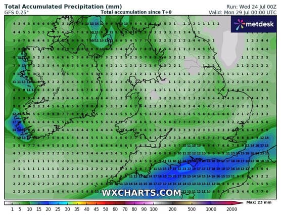
While there'll be some showers or rain at times, overall we'll see a good lot of dry bright weather over the weekend and into next week too. There'll be some nice sunshine at times and temperatures will pick up a little bit again too.
Friday night: Some clear spells in the midlands and east for a time on Friday with any showers tending to die away.
Cloud will continue to build from the west, with outbreaks of showery rain spreading eastwards, though it'll stay dry in eastern parts. A clearance to isolated showers will start to move in along the west coast though towards morning.
Lowest temperatures of 9 to 12 degrees in light to moderate south or southwest winds, a little fresher for a time in western coastal parts.
Saturday: The showery rain will continue to spread eastwards on Saturday morning, but it'll have cleared into the Irish Sea by the early afternoon.
Drier and sunnier weather along the west coast from early on will follow to all parts.
While there'll be a lot of dry weather for the rest of the day, a scattering of showers will develop though the afternoon and early evening, mainly in the midlands, east and north. It'll become dry in most places through the evening.
Highest temperatures of 17 to 21 degrees in light to moderate southerly winds veering west to northwesterly.
Saturday night: Saturday night will be dry with long clear spells, though with some mist and a few fog patches forming. High cloud will increase from the west though the night. Lowest temperatures of 7 to 10 degrees in light westerly or variable breezes.
Sunday: Any mist or fog will clear early in Sunday, to leave a dry, bright day with long spells sunshine, albeit rather hazy. It's likely to become a little cloudier later, especially further west.
Highest temperatures of 17 degrees along the west cost, up to 22 degrees further east, in light to moderate southwest breezes, which will likely become a little fresher later in some western and northwestern coastal parts.
Sunday night: Sunday night is likely to stay dry in many areas with a mix of cloud and clear spells, however it'll be cloudier further west and in the northwest with the chance of some rain and drizzle. Lowest temperatures of 9 to 13 degrees, in light to moderate southerly winds, fresher along the western and northwestern coasts.
Monday: There's some uncertainty in the detail from Monday onwards. A weather front which will be close to the west coast, will try to move in, bringing the chance of some rain and drizzle, mainly to the northwest and west.
Otherwise, it's likely to stay dry with a mix of cloud and sunshine. Highest temperatures of 17 to 22 degrees in light to moderate southwest winds, possibly fresher along western and northwestern coasts.
The uncertainty in detail continues for Tuesday and Wednesday, but overall, it looks like we'll have a good lot of dry weather with sunshine, but with a little rain likely in parts for a time on Tuesday and the chance of showers on Wednesday.
Highest temperatures of 18 to 24 degrees.