
WARNING: 'Over 10mm possible in six hours,' forecast for week ahead is NOT good!

Check this out!
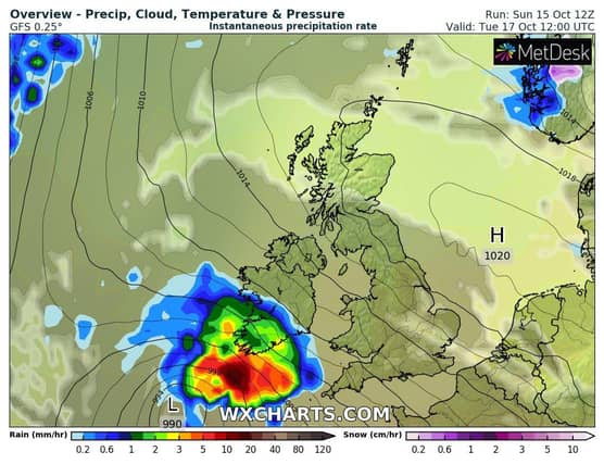
"Weather models a little uncertain around the timing of rain returning Tuesday but latest show it is likely to hit South by Tuesday afternoon and over 10mm possible in 6 hours near South coast Tuesday afternoon and early evening," according to forecaster Alan O'Reilly.
Met Éireann's five-day forecast is below:
Tuesday: It will become wet and breezy. Rain will spread across Munster, south Leinster and parts of south Connacht in the morning, before extending across the rest of the country during the afternoon. The rain will be heavy and thundery at times, so localised flooding is possible, particularly in the southwest. Highest temperatures of 9 to 14 degrees in a fresh to strong and gusty east to southeast wind.
National Outlook
Overview: Milder but unsettled with rain and showers every day.
Tuesday night: It will continue wet and breezy on Tuesday night, with rain moving northwards, followed by scattered showers. The rain will be heavy at times which may cause localised flooding. Lowest temperatures of 9 to 13 degrees in a moderate to fresh and gusty east to southeast wind, strong in coastal areas.
Wednesday: Wednesday will be cloudy with widespread outbreaks of rain, turning heavy at times. Milder than recent days, with highest temperatures of 13 to 16 degrees, in a moderate to fresh and gusty east to southeast wind, easing in southern areas later.
Wednesday night: On Wednesday night there will be more outbreaks of rain and it will be generally cloudy. Lowest temperatures of 8 to 13 degrees in a light to moderate easterly or variable wind.
Thursday: Thursday morning will be mostly cloudy with outbreaks of rain. Through the afternoon the rain will clear northwards, followed by scattered heavy showers and some sunny intervals. Highest temperatures of 13 to 16 degrees in a light to moderate easterly wind.
Thursday night: Mostly cloudy with scattered showers, some turning heavy. Lowest temperatures of 10 to 13 degrees in a light to moderate easterly wind.
Friday: Sunny spells and scattered heavy showers. Highest temperatures of 14 to 17 degrees in a mostly light to moderate easterly wind, possibly strengthening in the west.
Outlook for the weekend: Staying unsettled with further spells of rain and showers. Turning cooler too.