
Ireland Weather Channel forecaster 'fully expects' Storm Éowyn Status Red Warning

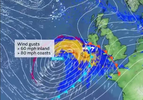

Alan O'Reilly predicts Met Éireann Storm Éowyn red and orange alerts for storm that could also bring snow
Cathal Nolan from Ireland's Weather Channel expects Storm Éowyan to bring winds of 150km/h to Ireland and believes Met Éireann will issue Red and Orange weather warnings for the storm.
The Met Office in the UK named the storm on Tuesday, January 21 ahead of the weather event which is set to sweep across Ireland and the UK for the end for the week.
Met Éireann has put Irish people on notice that the storm will caused damage so storm warnings will be issued.
"Based on the latest model guidance and with a view to providing an early advisory Ireland’s Weather Channel is issuing a Severe Weather Alert for late Thursday night, Friday morning and up to Friday afternoon for a spell of locally damaging winds as a deep storm depression passes close to the northwest coast of Ireland, or across Ulster depending on the final track," said Mr Nolan.
"With an estimated central pressure of 945hPa and with winds possibly gusting up to 170km/h in exposed coastal areas, with winds of up to 150km/h possible for coastal counties this storm is expected to bring widespread disruption across many parts of the country, however with over 48 hours before we have the final track and intensity finalised we advice staying up to date with our forecasts. MORE BELOW X POST.
"We expect that upper level weather warnings will be issued in due course due to the nature of the storm and the projected impacts, taking into account that this storm is likely to peak during the morning rush hour and throughout the morning on Friday across populated areas also. We fully expect to see Status Orange and Status Red weather warnings issued over the next 36 hours.
"There are likely to be subtle changes to the forecasts details during the coming 48 hours as this storm depression develops and arrives at our shores," concluded Mr Nolan.
Met Éireann has already issued a weather advisory for the entire country for the low pressure system which is currently deepening as it crosses the Atlantic.
Their advisory reads: "On Thursday night and Friday, a deepening Low-Pressure system, Storm Éowyn is forecast to track across Ireland. Very strong to gale force winds are expected across the country with the potential for damaging wind gusts and disruption in places. MORE BELOW X POST.
"Transitory falls of sleet and snow are expected too, especially across west and northwest counties. High seas and spells of heavy rain are expected also."
Met Éireann say it is "continuously monitoring the evolving situation and weather warnings will be issued as confidence in the forecast track/intensity of the Low-Pressure system improves."
They advised people to check the www.met.ie website and app for updates to forecasts and warnings in the coming days.
The Met Office in the UK has said the storm is being caused by Jet Stream winds which are the strongest of the winter.