
Met Éireann puts Ireland on New Year storm alert with freezing weather coming


Significant Atlantic wind and rain to be followed by very cold northerly air
Met Éireann is warning of potentially significant and impactful weather to end 2024 followed by a sharp cold snap to start the New Year.
The forecaster has already issued Status Yellow weather warnings for New Year's Eve and Day for wind and rain caused by weather fronts sweeping in from the Atlantic.
In a commentary on what's to come Met Éireann says a series of low-pressure centres in the Atlantic are likely to pass over the country on Tuesday followed by another more significant area of low pressure on New Year's Day, Wednesday.
It says Tuesday’s weather is expected to be very unsettled with heavy rain passing down over the country throughout the day.
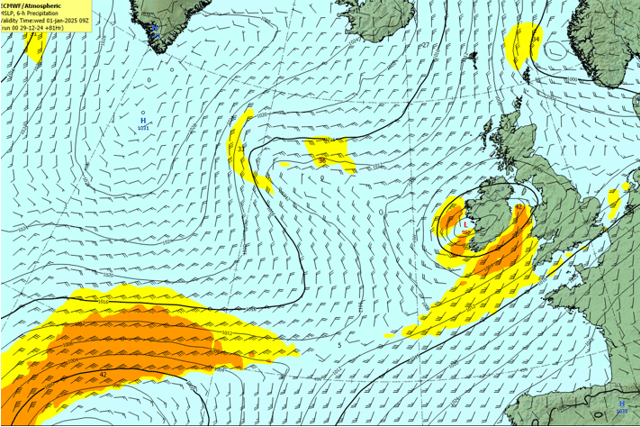
“the low moving over on Tuesday will bring significant winds to the northwest but rain will be widespread and rather heavy at times too which could lead to spot flooding," he said.
The forecaster said Wednesday will prove to be a lot more significant with more rain and very strong and blustery winds for all areas.
“We are currently tracking the development of the low pressure system expected for Wednesday with potentially some very impactful winds across western and southern areas,” he said.
Met Éireann expects the low to track right across the country with significant winds expected for western and southern areas.
The Met Éireann flood forecasting centre says that soils are saturated or approaching saturation countrywide which will increase rainfall runoff to the rivers. It warns that the widespread and prolonged nature of the rain may lead to significant river level increases. There is the potential for surface water flooding where highest rainfall totals are observed.
They added that with spring tides, significant surge, wind and wave conditions are expected. While coastal inundation is not expected, exposed low-lying coastal areas may experience wave overtopping due to strong on-shore winds coinciding with high tide.
Met Éireann is forecasting a cold change with very cold northerly air set to sink down across the country to finish out the week after the stormy weather ends. Temperatures are likely to fall well below freezing overnight and struggle to remain in the single figures during the day.

Monday: A blustery day today with outbreaks of rain across parts of Ulster and Connacht. Elsewhere will be dry with just isolated patches of drizzle and a few sunny spells developing. Highest temperatures of 9 to 12 degrees with fresh to strong and gusty southwest winds, easing moderate to fresh in the afternoon.
Becoming windier overnight with rain gradually spreading southeastwards across the country, turning heavy in places. Southwest winds will increase fresh to strong and gusty, reaching near gale force in the west. Lowest temperatures of 6 to 9 degrees.
Tuesday New Year's Eve: A rather windy day with widespread rain at first. Rain will become confined to Munster and south Leinster in the afternoon, with sunny spells and isolated showers elsewhere. Highest temperatures of 9 to 12 degrees in fresh to strong and gusty southwest winds, easing during the evening.
Rain in the southwest continues to extend northeastwards overnight, heavy in places, with spot flooding possible. Some falls of sleet and snow may occur also. More showery conditions are likely in the north. There is the chance of strong winds in the south but they may stay off shore. MORE BELOW X POST.
Wednesday New Years Day: Will see heavy rain for a time, mainly in the east and south, with some falls of sleet or snow possible too. This will clear away southeastwards during the day. It may be windy in parts for a time too with winds becoming northwesterly and gradually easing. Some sunny spells will develop with showers in parts. Highest temperatures of 5 to 8 degrees, but it'll become cold everywhere through the evening.
Becoming mostly dry early in the night as winds ease northerly. Cold with lowest temperatures of -5 to +1 degrees with widespread frost and ice developing. A few wintry flurries are possible in the north.
Thursday: Largely dry, sunny and cold with just a few light showers along north-facing coasts, some wintry. Highest temperatures of 1 to 5 degrees generally in mostly light northerly winds. Mostly dry, clear and cold overnight. Lowest temperatures of -6 to +1 degrees with widespread frost.
Very cold, largely dry and bright for the following few days with widespread frosts developing during the nights, stubborn to clear some areas during the days. There'll be well-scattered wintry showers too, mainly in northern and some western parts. Some fog and freezing fog will develop by night too, slow to clear by day.