
Storm Ciarán officially declared as Met Éireann puts Ireland on weather alert

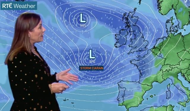

Storm Ciarán is set to hit Ireland this week according to Met Éireann which has outlined where what parts of the country will be worst impacted by the third storm of the season so far.
Senior Met Éireann weather forecaster outlined what to expect in her weekly outlook on RTÉ on the farming forecast. She indicated that while Ireland might escape the worst of Storm Ciarán's impact, it comes on the back of very wet weather which has saturated many places.
Ms Ryan said up to four times the average rain had been recorded in the past week in at its weather station in Wexford. Storm Ciarán will be the central feature of another bad week.
"Over the next seven days, it is looking extremely unsettled. We are looking at frequent spells of heavy rain in blustery conditions potentially stormy particularly midweek and again next weekend.
"The ground is saturated or waterlogged. The river levels remain high and there is a lot of surface water. With the recent super moon high tides remain an issue for the south and east of Ireland, she said.
The meteorologist said that there'd be some respite on Tuesday, Halloween but things would deteriorate on Wednesday.
"Storm Ciarán potentially clipping the south and east of Ireland during Wednesday evening and for a time on Thursday," she said.
Beyond that, Ms Ryan said the weather forecast looks 'unfavourable'.
Met Éireann said Storm Ciarán was declared by its weather forecasting partner in the UK the Met Office. It follows on quickly from Storm Agnes and Strom Babet which caused bad flooding in Ireland and the UK. MORE BELOW TWEETs.
MET Éireann National Forecast issued at 11.34am on Sunday, October 29.
National Outlook Overview: Staying unsettled, with a spell of very wet and windy weather possible later in the week.
Sunday: Afternoon and evening there will be a mix of sunny spells and showers, heaviest over the northern half of the country and in west Munster with spot flooding. Highest temperatures of 11 to 13 degrees with a moderate to fresh easterly breeze in Ulster, light and variable elsewhere.
Mix of clear spells and scattered showers at night, most frequent in Munster and Ulster. Winds will be light and variable in most areas, so mist and fog will form, but there will be a moderate to fresh easterly wind in the north. Lowest temperatures of 1 to 5 degrees generally but not as cold in the north.
Monday: Mist and fog will slowly clear. Dry at first in many areas. Heavy showers will move into the south during the morning and will track northwards through the day, merging into longer spells of rain at times and possibly causing localised flooding. Scattered showers in the north. Highest temperatures of 10 to 13 degrees with light to moderate easterly or variable wind.
Showers or longer spells of rain early in the night, but most places will become dry overnight. Winds will be light and variable so areas of mist and fog will form. Lowest temperatures of 3 to 7 degrees.
Tuesday: Rain will move into the southwest on Tuesday morning and will track northeast across the country, reaching Ulster by evening. Highest temperatures of 10 to 14 degrees with moderate east to southeast winds developing.
It will stay wet on Tuesday night with further outbreaks of rain across the country, heavy at times. Lowest temperatures of 7 to 10 degrees with moderate to fresh southeasterly winds.
Wednesday: Rain will clear northeastwards during Wednesday morning and afternoon, with sunny spells and some showers following. More rain is forecast to move into the southwest later in the afternoon though, extending across the southern half of the country during the evening. Heaviest rain is expected in Munster and south Leinster, with flooding possible. The rain will also be accompanied by strong easterly winds. Highest temperatures of 9 to 12 degrees.
Wednesday night and Thursday: A spell of wet and windy or stormy weather is possible, depending on the track of a low pressure system close to Ireland.