
Shoppers shocked as mop is used in bare-chested brawl inside Irish shopping centre
Search
09 Sept 2025
Please allow ads as they help fund our trusted local news content.
Kindly add us to your ad blocker whitelist.
If you want further access to Ireland's best local journalism, consider contributing and/or subscribing to our free daily Newsletter .
Support our mission and join our community now.
To continue reading this article, you can subscribe for as little as €0.50 per week which will also give you access to all of our premium content and archived articles!
Alternatively, you can pay €0.50 per article, capped at €1 per day.
Thank you for supporting Ireland's best local journalism!

Snow clearance work in 2023 at Laois County Council in Portlaoise.

Met Éireann has put Ireland on alert for 'very disruptive' weather with significant snow on the cards caused by the freezing artic air that his plunged down over the country.
In its outlook for the days ahead as the Christmas and New Year holidays end, Met Éireann warns of what's to come.
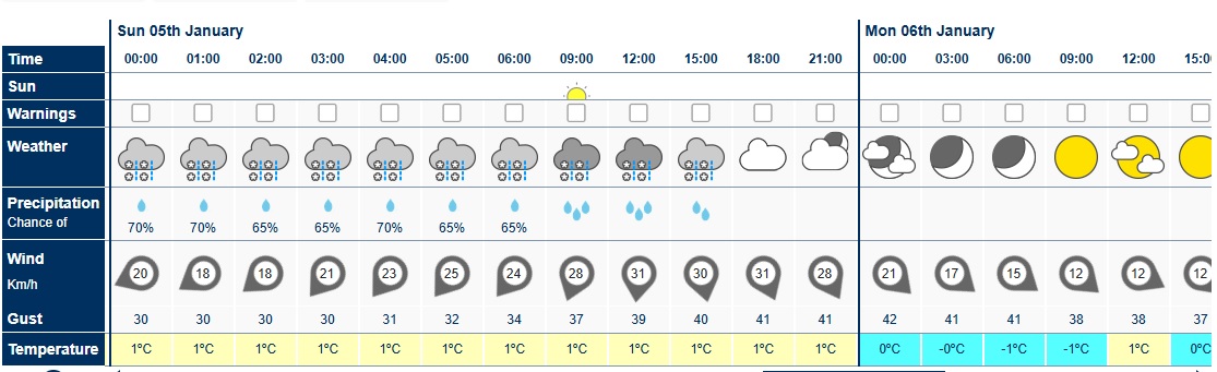
"It will be very cold with some very disruptive and impactful weather likely this weekend, with an area of low-pressure dominating and bringing heavy rain, sleet and some disruptive amounts of snow," said the forecaster on January 2.
Met Éireann says the first of the significant wintry precipitation will hit at the weekend as an area of low pressure from the Atlantic collides with the cold weather over Ireland.
"The area of low pressure is likely to track eastwards close to or over southern parts of the country on Saturday night, bringing widespread heavy falls of rain, sleet and snow on Saturday night," says the forecaster.
These conditions will persist through the weekend but the wintry precipitation will clear gradually.
"Sunday will bring further falls of rain, sleet and some further significant snowfall accumulations for a time. It'll gradually become drier from the west later in the day as the area of low pressure moves away eastwards," said the fore cater.
As many return to school and work on Monday, Met Éirenn warns that the cold weather is not going away.
"An arctic airmass will bring bitterly cold conditions next week. There'll be treacherous conditions with some significant accumulations of lying snow along with widespread severe frost and ice.
"The cold snap of weather will continue to the end of next week, with the likelihood of more persistent falls of rain, sleet and snow, but it's likely to gradually become less cold by the weekend," says Met Éireann in its online forecast on January 2.
The forecaster has caused Met Éireann to issue a Weather Advisor for the coming weekend.
Read Met Éireann National Forecast issued at 9.40am on January 2 for the coming days below X post.
A weather advisory has been issued as sleet and snow are expected in some parts of the country. ❄️
— Met Éireann (@MetEireann) January 2, 2025
Valid from: Saturday 04/01/2025 to Monday 06/01/2025
For more information, visit: https://t.co/IMZz9b975Q pic.twitter.com/YxOfm6rtVz
Thursday: Frost and any ice will clear to leave a cold day and it'll be dry and sunny in many areas. There'll be scattered showers though, mainly in Ulster and Connacht, some of hail and sleet. There'll be a few snow flurries too, mainly in the north. Highest temperatures of only 2 to 6 degrees in a light to moderate mainly north to northwest breeze.
Cold night with clear spells and while it'll be dry in most areas, there'll be well scattered showers, mainly in the north and west, some wintry. Lowest temperatures of -5 to 0 degrees with widespread frost and some ice developing. Some fog and freezing fog will form too. Winds will be mostly light west to northwesterly or variable, but will be fresher in northern coastal parts.
Friday: It'll be frosty to begin with some fog in places too. The frost and fog will clear to leave another cold day, but it'll be dry and sunny again in many areas. However there'll be scattered showers, mainly in the north and some in the west, a few wintry, and with more persistent rain for a time in north Ulster. Highest temperatures of 2 to 6 degrees in mostly light to moderate westerly or variable breezes, the winds fresher for a time in coastal parts of the north and northeast. MORE BELOW PICTURE.
Staying cold and mainly dry with clear spells. There'll be a few well scattered showers near western and northern coasts, the odd wintry one. Lowest temperatures of -3 to +1 degrees, with widespread frost and some ice forming once again. There'll be also be some fog and freezing fog patches.
Saturday: The frost and fog will clear on Saturday morning and it'll be dry for a time in many areas with some sunny spells, especially further north. However, it now looks increasingly likely that an area of low pressure to the south of Ireland, will dominate our weather for the rest of the weekend, with rain gradually spreading from the southwest over the course of the day, becoming heavy at times, especially later and as it meets the cold air further inland, it'll turn to sleet and snow. Cold with highest temperatures of just 1 to 6 or 7 degrees, with the higher temperatures along the south and southwest coast, where the precipitation will fall mainly as rain. Winds will be mostly light easterly to begin, but will freshen through the day.
The area of low pressure is likely to track eastwards close to or over southern parts of the country on Saturday night, bringing widespread heavy falls of rain, sleet and snow on Saturday night. The precipitation will mainly fall as sleet and snow away from the south and southwest, with some significant accumulations expected. Lowest temperatures of -2 to +1 degrees in moderate to fresh and gusty east to northeast winds, stronger in some coastal parts.
Sunday: Sunday will bring further falls of rain, sleet and some further significant snowfall accumulations for a time. It'll gradually become drier from the west later in the day as the area of low pressure moves away eastwards. Feeling very cold with highest temperatures of 2 to 7 degrees and with the added wind chill from fresh and gusty northerly winds, strong at times in some coastal parts.
Any remaining rain, sleet and snow will clear eastwards on Sunday night, with clear spells following. Scattered rain, hail, sleet and snow showers will follow too, mainly into the north and west. Very cold with some significant amounts of lying snow, widespread frost and ice. Lowest temperatures of -5 to 0 degrees with the north to northwest winds generally moderating.
Monday: Very cold with some bright or sunny spells and scattered showers of rain, hail, sleet and snow, these most frequent in the north and west. Highest temperatures ranging from freezing to 5 degrees in mostly moderate northwest winds, fresher in coastal parts of the north and west.
Very cold with some clear spells and further scattered wintry showers, these mainly in the north and west. Lowest temperatures of -7 to -1 degrees with widespread severe, frost, ice conditions. Winds will be mostly light to moderate northwesterly, fresher in coastal parts of the north and northwest.
Tuesday: Another very cold day with treacherous icy conditions and lying snow. Overall there'll be a lot of dry bright, sunny weather, but still some scattered showers in the north and west. Highest temperatures of just -1 to +4 degrees in light to moderate west to northwest winds.
Apart from a few lingering wintry showers in the north, it'll be dry on Tuesday night with clear spells. Freezing fog will form, becoming dense in places. Extremely cold with temperatures expected to fall to between -10 and -3 degrees in light variable breezes.
Wednesday: Bitterly cold on Wednesday with freezing fog, lying snow and icy conditions. Mainly dry, with just well scattered showers in the north and northwest. Daytime temperatures could be as low as -5 to +2 degrees.
The cold snap of weather will continue to the end of next week, with the likelihood of more persistent falls of rain, sleet and snow, but it's likely to gradually become less cold by the weekend.

Subscribe or register today to discover more from DonegalLive.ie
Buy the e-paper of the Donegal Democrat, Donegal People's Press, Donegal Post and Inish Times here for instant access to Donegal's premier news titles.
Keep up with the latest news from Donegal with our daily newsletter featuring the most important stories of the day delivered to your inbox every evening at 5pm.
This publication supports the work of the Press Council of Ireland and Office of the Press Ombudsman, and our staff operate within the Code of Practice of the Press Council. You can obtain a copy of the Code, or contact the Council, at www.presscouncil.ie, Lo-call 1800 208 080 or email: info@presscouncil.ie.


