 as heartbreaking statement is issued")
RIP: Body found in search for missing man (63) as heartbreaking statement is issued
Search
10 Mar 2026
Please allow ads as they help fund our trusted local news content.
Kindly add us to your ad blocker whitelist.
If you want further access to Ireland's best local journalism, consider contributing and/or subscribing to our free daily Newsletter .
Support our mission and join our community now.
To continue reading this article, you can subscribe for as little as €0.50 per week which will also give you access to all of our premium content and archived articles!
Alternatively, you can pay €0.50 per article, capped at €1 per day.
Thank you for supporting Ireland's best local journalism!


Newly digitised maps and records from the former owners of Ballyfin Demesne have been released, showing a snapshot of life in Laois in 1813.
The Delany Archive Trust, responsible for the care of archives belonging to the Diocese of Kildare and Leighlin, the Brigidine Sisters and the Patrician Brothers have released dozens of maps and land records belonging to Sir Charles Henry Coote.
A survey of the Coote estate was undertaken from 1813 to 1814 by Dublin surveyors Thomas Logan & Son.
These records show payments made for the rent of land and property, including the names of lessees and occupying tenants across the 73 townlands and denominations across the west of Laois.
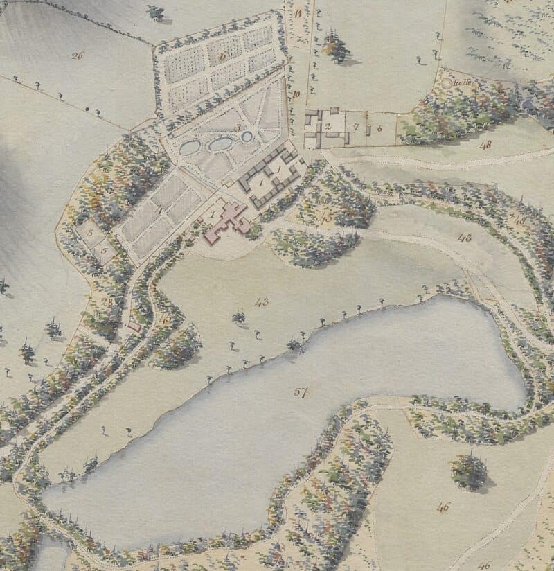
Pictured: Ballyfin House, 1813
Nowadays an internationally famous exclusive hotel, Ballyfin’s rich history saw it as a home to the O’Moores, the Crosbys, the Poles, the Wellesley-Poles and the Cootes.
The house was built in the 1820s for Sir Charles Coote, and designed by the well known architects Sir Richard and William Morrison.
A survey of Ballyfin Demesne was divided up into 57 features in an index. There was an abundance of gardens on the grounds, including the melon garden, the flower garden, the kitchen garden, the middle garden, Moore's garden and Hutchinson's garden, along with dozens of meadows and plantations.
The various lawns, the lake and the church were recorded as amenities on the grounds, a quiet and beautiful landscape in a similar state to the luxury hotel it is today.
In Mountrath, Sir Coote received regular payments for the rent of cabins and houses, with many landowners renting gardens and land.
Records show rent paid by individual tenants and businesses. Annual payments were made for the Quaker's burial ground, the Catholic Church and churchyard. Records concerning the brewery and Manor Hill are available for viewing.
An index shows the amount made annually by Sir Charles Henry Coote, divided up by each townland.
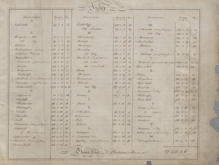
Pictured: Index of rent paid from 73 townslands to the Coote Estate, 1813
This project has been funded by The Heritage Council, supporting the digitising of two volumes of the collection.
The 1813 volume provides detailed reference information identifying lessees and occupying tenants (where provided), along with descriptions of the location, quality, and quantity of their holdings.
The 1815 volume contains estate maps of the demesne lands at Ballyfin and the tenanted estate, accompanied by similar reference information to that found in the 1813 volume.
"These resources offer valuable insights into landholding and estate management in early 19th-century Ireland, as well as detailed maps that predate the Ordnance Survey," a representative of the Delany Archives praised.
A map and list of tenants from each area is available to view online through the Delany archives here.

Subscribe or register today to discover more from DonegalLive.ie
Buy the e-paper of the Donegal Democrat, Donegal People's Press, Donegal Post and Inish Times here for instant access to Donegal's premier news titles.
Keep up with the latest news from Donegal with our daily newsletter featuring the most important stories of the day delivered to your inbox every evening at 5pm.
This publication supports the work of the Press Council of Ireland and Office of the Press Ombudsman, and our staff operate within the Code of Practice of the Press Council. You can obtain a copy of the Code, or contact the Council, at www.presscouncil.ie, Lo-call 1800 208 080 or email: info@presscouncil.ie.


 killed after being struck by car as gardaí appeal for witnesses")


