Search
20 Apr 2026
Search
20 Apr 2026
Please allow ads as they help fund our trusted local news content.
Kindly add us to your ad blocker whitelist.
If you want further access to Ireland's best local journalism, consider contributing and/or subscribing to our free daily Newsletter .
Support our mission and join our community now.
To continue reading this article, you can subscribe for as little as €0.50 per week which will also give you access to all of our premium content and archived articles!
Alternatively, you can pay €0.50 per article, capped at €1 per day.
Thank you for supporting Ireland's best local journalism!

Aerial photograph captured by Luftwaffe of the Leitrim-Donegal Border, photo courtesy of Éamon Ó Caoineachán

The Leitrim-Donegal border played an unexpected role in Nazi Germany’s secret plans during World War Two.
Éamon Ó Caoineachán, locally known as Eddie Keenaghan, is an Irish poet, writer, and historian living in Texas and originally from Bundoran.
He has been researching “Operation Green,” which was Nazi Germany’s 1940-1941 plan to use Ireland as a foothold against Britain.
Éamon revealed that the Luftwaffe captured an aerial photograph of the Drowes River on the Leitrim-Donegal border, mistakenly identifying it as the Bradóg River.
“The Nazis clearly didn't know the Donegal-Leitrim border all too well when they considered planning to invade Ireland during Operation Green, but their air force, the Luftwaffe, knew it well enough to capture an aerial photograph of it,” said Éamon.
Incredibly, the border was chosen as a possible landing site for the planned invasion.
Although the plan was abandoned after Germany’s defeat in the Battle of Britain, Éamon described the prospect of the invasion as “alarming, especially how it would have traumatically impacted the local communities who had recently experienced colonisation.”
Éamon first learned about the photographs in 2012 after reading a Journal.ie article and was again reminded of them through historian Marc McMenamin’s research in 2020.
He later received the Nazi military booklet Militärgeographische Angaben über Irland (Military Geographical Data on Ireland) by a colleague from Harvard, where he discovered the photograph of the Leitrim-Donegal border.
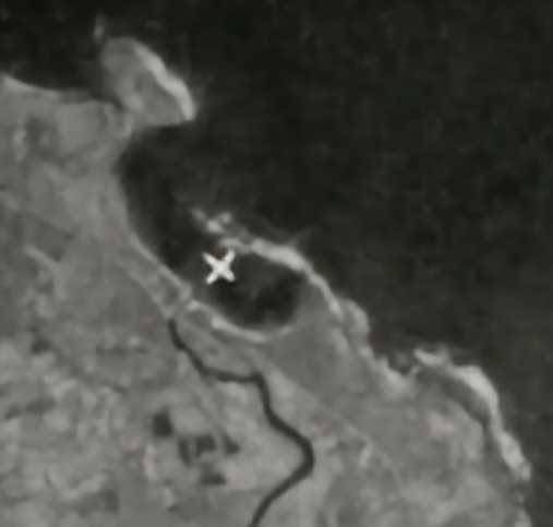
Bundoran historian Seanie Carty noted that the chosen landing spot would have been disastrous. “That spot where the X is would probably be the worst possible place to land that they could have chosen. It would almost certainly have ended in the death of all involved,” he said.
From discussions Éamon had with Seanie Carty, and historian Joe McGowan, they all agreed that the Nazi’s likely had an informant in the Leitrim and Donegal areas given their strategic awareness of sites like the Donegal corridor.
Éamon suggested that Nazi professor and suspected German spy Dr Ludwig Mühlhausen may have played a role.
“The Wild Atlantic Way could have ended up tragically living up to its wild name in the worst imaginable way, if the Nazis invaded Ireland - twenty years after Ireland's fight for Independence,” Éamon said.
Mr Carty also made the point of the controversial history of Irish neutrality in the area at the time. “The Éire sign during WWII that was on Rougey - unlike the other signs on the coast, that one wasn't put in place by the Irish government. It was put there by local Republicans in protest of American and British planes using the Donegal Corridor.”
Little did many locals know at the time, as Éamon put it, “that the dreaded Nazis were spying on foot and were also flying overhead.”
READ MORE: Fine and conviction imposed after Leitrim pub was found to have no licence

Subscribe or register today to discover more from DonegalLive.ie
Buy the e-paper of the Donegal Democrat, Donegal People's Press, Donegal Post and Inish Times here for instant access to Donegal's premier news titles.
Keep up with the latest news from Donegal with our daily newsletter featuring the most important stories of the day delivered to your inbox every evening at 5pm.
This publication supports the work of the Press Council of Ireland and Office of the Press Ombudsman, and our staff operate within the Code of Practice of the Press Council. You can obtain a copy of the Code, or contact the Council, at www.presscouncil.ie, Lo-call 1800 208 080 or email: info@presscouncil.ie.


