
The woman was conveyed to University Hospital Limerick for treatment of serious injuries. She was pronounced deceased yesterday evening.
Search
01 Apr 2026
Please allow ads as they help fund our trusted local news content.
Kindly add us to your ad blocker whitelist.
If you want further access to Ireland's best local journalism, consider contributing and/or subscribing to our free daily Newsletter .
Support our mission and join our community now.
To continue reading this article, you can subscribe for as little as €0.50 per week which will also give you access to all of our premium content and archived articles!
Alternatively, you can pay €0.50 per article, capped at €1 per day.
Thank you for supporting Ireland's best local journalism!


Hurricane Lee will bring “heavy and persistent” showers to western areas of the UK on Tuesday.
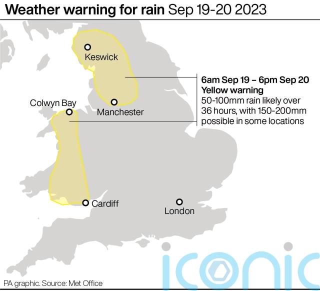
The Met Office said remnants of the hurricane, which hit New England in the US and eastern Canada, would particularly affect parts of west Wales, Cumbria and the Pennines, with a yellow rain warning in place.
It will no longer be a hurricane by the time it reaches UK shores.
Strong winds will also pick up across England and Wales, with coastal gales developing in the west.
It comes after thunderstorms in the south-west of England on Sunday led to heavy rain and flash floods.
A Butlin’s holiday resort in Minehead, Somerset said it would be closed for four days after its site was damaged by the torrential downpours.
Exeter Airport was also forced to close and cancel its remaining flights on Sunday.
The Met Office said showers were “highly localised”, with the airport seeing 57.4mm of rainfall, while Swindon in Wiltshire received 90.7mm overnight, with the average rainfall for the entire month of September in the county about 61mm.
⚠️ Yellow weather warning issued ⚠️
Rain across much of Wales and North West EnglandTuesday 0600 – Wednesday 1800
Latest info 👉 https://t.co/QwDLMfRBfs
Stay #WeatherAware⚠️ pic.twitter.com/iHCNcBgPoL
— Met Office (@metoffice) September 18, 2023
These showers have since shifted to areas in the East Midlands, with Nottingham and parts of Lincolnshire seeing 40-45mm of rainfall on Monday.
About 10,000 lightning strikes were recorded across the UK on Sunday, with a further 800 recorded across Yorkshire and North East England on Monday.
Dan Stroud, meteorologist at the Met Office, said: “We’re undergoing a change at the moment, we’ve got a cold front moving in from the west, so that is helping to clear out all the showers and thunderstorms we had yesterday which have been shunted eastwards out into the North Sea.”
Looking ahead to Tuesday, the forecaster said conditions would be mostly cloudy with an area of rain moving in from the west, with a yellow rain warning in place for parts of west Wales, Cumbria and the Pennines.
The best of the weather will be in Scotland, which will be cloudier but with lighter winds.
Windy conditions are likely to continue on Wednesday but will gradually ease.
The Met Office added there would be more focus on blustery showers and sunny spells on Thursday and Friday, with a “generally unsettled” outlook over the next week or so.

Subscribe or register today to discover more from DonegalLive.ie
Buy the e-paper of the Donegal Democrat, Donegal People's Press, Donegal Post and Inish Times here for instant access to Donegal's premier news titles.
Keep up with the latest news from Donegal with our daily newsletter featuring the most important stories of the day delivered to your inbox every evening at 5pm.
This publication supports the work of the Press Council of Ireland and Office of the Press Ombudsman, and our staff operate within the Code of Practice of the Press Council. You can obtain a copy of the Code, or contact the Council, at www.presscouncil.ie, Lo-call 1800 208 080 or email: info@presscouncil.ie.


