Search
22 Apr 2026
Search
22 Apr 2026
Please allow ads as they help fund our trusted local news content.
Kindly add us to your ad blocker whitelist.
If you want further access to Ireland's best local journalism, consider contributing and/or subscribing to our free daily Newsletter .
Support our mission and join our community now.
To continue reading this article, you can subscribe for as little as €0.50 per week which will also give you access to all of our premium content and archived articles!
Alternatively, you can pay €0.50 per article, capped at €1 per day.
Thank you for supporting Ireland's best local journalism!


The UK will be “brighter” on Sunday, ahead of a blast of snow and rain towards New Year’s Eve, the Met Office has said.
Highs of 12C are expected in Exeter, Devon, with 10C across other parts of the country country including Belfast, Newcastle-upon-Tyne, Pembrokeshire and Southampton, according to the forecaster.
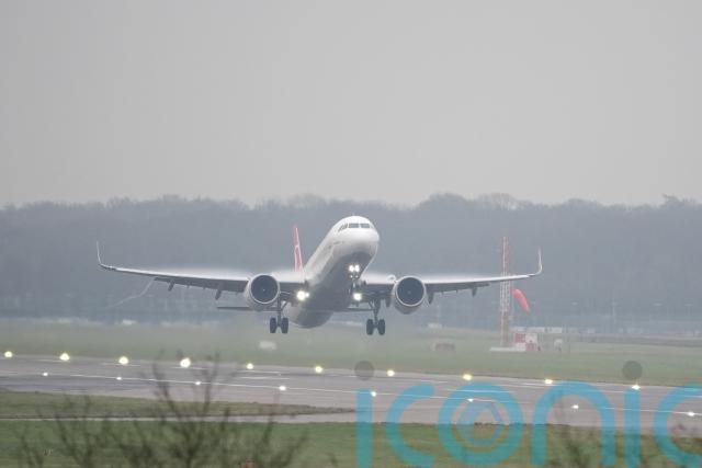
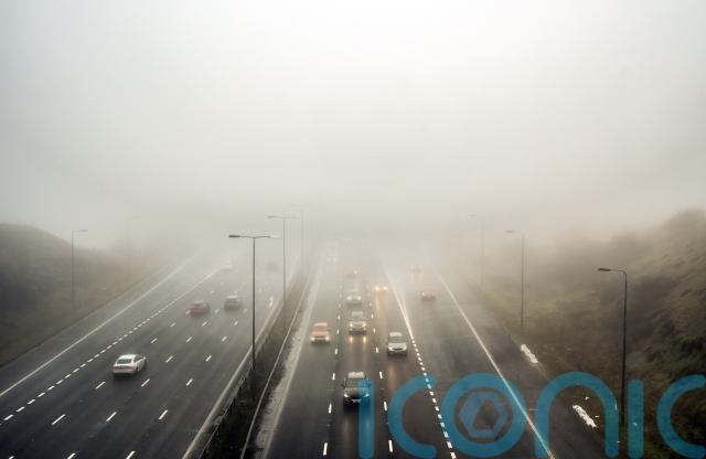
The fog, which shrouded the country over Friday and Saturday – causing delays at multiple airports including Gatwick and Manchester – is largely set to dissipate by Sunday afternoon.
South-east England will see a “dull start” to the day with “brighter conditions” later on, while northern parts of the country will be “quite windy”, with heavy downpours moving across Scotland, the weather service said.
The Met Office has issued two yellow weather warnings for Monday and Tuesday – with up to 140mm of rain, 20cm of snow and 60mph winds possible in the worst-affected areas during the run-up to New Year’s Eve.
The warning for snow and rain covers most of Scotland – which is braced for heavy downpours which may bring “significant disruption” in the build-up to Hogmanay.
Remaining cloudy this evening with patchy drizzle, mist and fog across England and Wales
Outbreaks of rain across Scotland and Northern Ireland continuing to move southeastwards with a mix of clear spells and showers following pic.twitter.com/g6DcFLuxVW
— Met Office (@metoffice) December 28, 2024
Of Sunday’s weather, senior forecaster Craig Snell said: “We should see a brighter day across the UK.
“It could still be a bit dull to start across kind of the South East, especially, but as the day goes on, we should see some brighter, brighter weather develop even there.
“It’s not going to be wall-to-wall sunshine, but we certainly hopefully have lost a lot of the murk we’ve seen for the last day or so.”
The outlook towards New Year’s Eve is “unsettled” with blustery and wet conditions set to hit the north of the country with “less expansive” rain in the south.
The weather warning for snow and rain is in place on December 30 and 31 for most of Scotland, apart from Orkney and Shetland, during which 50-70mm of rain is possible and up to 140mm in the west.
Between 10 and 20cm of snow is expected to accumulate on higher ground with flakes expected to fall in areas north and east of Perthshire, according to the forecaster.
The weather is set to turn widely unsettled as we see out the last few days of 2024, with potentially some wet and very windy weather at times
Weather warnings are already in force for Monday and New Year's Eve across parts of the north ⚠️ pic.twitter.com/fEoUrCGXkL
— Met Office (@metoffice) December 28, 2024
A separate warning for wind in northern England on Monday has also been issued – with gusts of up to 60mph possible which may cause travel delays and power cuts.
The warning, in place from 11am to 6pm, covers areas including Durham, Northumberland, Cumbria and North Yorkshire.

Subscribe or register today to discover more from DonegalLive.ie
Buy the e-paper of the Donegal Democrat, Donegal People's Press, Donegal Post and Inish Times here for instant access to Donegal's premier news titles.
Keep up with the latest news from Donegal with our daily newsletter featuring the most important stories of the day delivered to your inbox every evening at 5pm.
This publication supports the work of the Press Council of Ireland and Office of the Press Ombudsman, and our staff operate within the Code of Practice of the Press Council. You can obtain a copy of the Code, or contact the Council, at www.presscouncil.ie, Lo-call 1800 208 080 or email: info@presscouncil.ie.


