Search
21 Oct 2025
Search
21 Oct 2025
Please allow ads as they help fund our trusted local news content.
Kindly add us to your ad blocker whitelist.
If you want further access to Ireland's best local journalism, consider contributing and/or subscribing to our free daily Newsletter .
Support our mission and join our community now.
To continue reading this article, you can subscribe for as little as €0.50 per week which will also give you access to all of our premium content and archived articles!
Alternatively, you can pay €0.50 per article, capped at €1 per day.
Thank you for supporting Ireland's best local journalism!


Heavy downpours and winds of up to 75mph are set to batter the UK this week, forecasters said as three weather warnings were issued.
On Thursday, the wet and windy conditions may cause travel disruption, flooding, power cuts and damage to buildings within the alert areas, according to the Met Office.
A yellow weather warning for rain covers most of southern England, the east Midlands, parts of Wales and Yorkshire and is in place all of Thursday until 9pm, the forecaster said.
Those within the affected regions have been warned by the weather service to expect heavy rainfall from Wednesday evening with up 50mm in some areas by early Thursday morning.
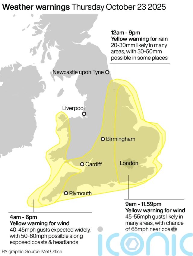
Some areas, particularly North Devon, Cornwall and in the east of England, could exceed this amount of rain, the Met Office added.
The downpours may cause disruption to public transport, difficult driving conditions because of spray and road flooding as well as the flooding of some homes and businesses, the forecaster said.
A separate warning for wind on Thursday is in place from 9am until 11.59pm, covering the east of England up to Scarborough where gusts of up to 75mph may develop.
For the majority of the yellow alert area, gusts of up to 55mph are expected with 65mph possible near coasts, the Met Office said.
Strong winds may lead to power cuts, transport disruption and damage to buildings with a small chance of injuries and danger to life caused by large waves and beach material being thrown onto seafronts and coastal roads, the forecaster warned.
⚠️Yellow weather warning issued ⚠️
Strong winds in west Wales and southwest England
Thursday 0400 -1800
Latest info 👉 https://t.co/QwDLMfS950
Stay #WeatherAware⚠️ pic.twitter.com/HIvN5GCh0L
— Met Office (@metoffice) October 21, 2025
Another yellow alert for wind on Thursday covers southwest England and parts of Wales, including Somerset, Devon, Cornwall, Swansea and Pembrokeshire.
Gusts of up to 45mph are expected widely within this area, while winds of up to 60mph could be reached along exposed coasts and headlands, according to the forecaster.
In an online forecast, Met Office meteorologist Aidan McGivern said some “very unsettled weather” caused by low pressure was expected from Wednesday night into Thursday.
He said: “The low is deepening as it crosses the UK, it’s likely to bring a swathe of strong winds as well, gales around southern and eastern coasts, the risk of 60-mile-per hour gusts in some exposed spots, perhaps even a touch more in places.”
Before Wednesday, conditions are expected to be a “mix of bright spells and showers”, he added.
RAC spokesman Rod Dennis said: “Thursday is set to be a challenging day for drivers, with the evening commute likely to be a very wet and windy affair for many.
“We urge drivers to slow down according to the conditions, leaving a much bigger gap between themselves and the vehicle in front, and be wary of the buffeting effect of the wind when they pass high-sided vehicles.
“On more rural routes, flooding is a very real possibility so drivers must never be tempted to risk it by driving through standing water unless they’re confident it’s shallow enough to get through safely – it’s always better to turn around and find another route.
“Those taking to the roads on Friday should also be extra vigilant, as branches and other debris may have been blown onto roads – another reason why driving more slowly in these sorts of weather conditions is so important.”

Subscribe or register today to discover more from DonegalLive.ie
Buy the e-paper of the Donegal Democrat, Donegal People's Press, Donegal Post and Inish Times here for instant access to Donegal's premier news titles.
Keep up with the latest news from Donegal with our daily newsletter featuring the most important stories of the day delivered to your inbox every evening at 5pm.
This publication supports the work of the Press Council of Ireland and Office of the Press Ombudsman, and our staff operate within the Code of Practice of the Press Council. You can obtain a copy of the Code, or contact the Council, at www.presscouncil.ie, Lo-call 1800 208 080 or email: info@presscouncil.ie.


