Search
22 Apr 2026
Search
22 Apr 2026
Please allow ads as they help fund our trusted local news content.
Kindly add us to your ad blocker whitelist.
If you want further access to Ireland's best local journalism, consider contributing and/or subscribing to our free daily Newsletter .
Support our mission and join our community now.
To continue reading this article, you can subscribe for as little as €0.50 per week which will also give you access to all of our premium content and archived articles!
Alternatively, you can pay €0.50 per article, capped at €1 per day.
Thank you for supporting Ireland's best local journalism!


Storm Benjamin, as named by Meteo France, is set to batter the UK with heavy downpours and winds of more than 70mph this week, forecasters have said.
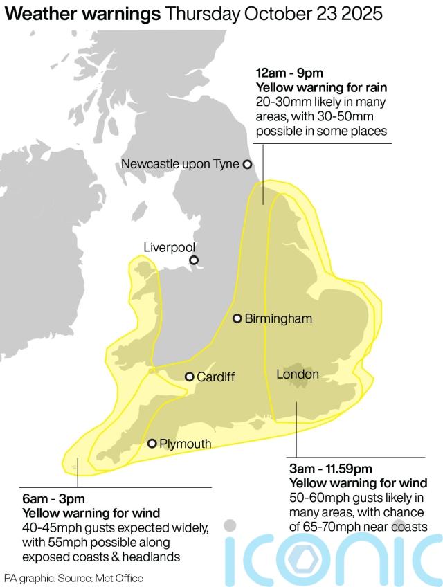
The Met Office has released three yellow weather warnings over possible disruption, flooding, power cuts and damage to buildings in a number of areas on Thursday.
A yellow weather warning for rain covering most of southern England, the East Midlands, parts of Wales and Yorkshire will be in place until 9pm.
Those within the affected regions have been warned by the weather service to expect heavy rainfall from Wednesday evening, with up to 50mm in some areas by early Thursday.
The anticipated wet and windy conditions have not yet earned the storm an official name from the Met Office.
A separate warning for wind on Thursday is in place from 9am until 11.59pm, covering the east of England from Brighton up to Scarborough.
For the majority of the yellow alert area, gusts of up to 55mph are expected, with 65mph possible near coasts, the Met Office said.
Strong winds may lead to power cuts, transport disruption and damage to buildings with a small chance of injuries and danger to life caused by large waves and beach material being thrown onto seafronts and coastal roads, the forecaster warned.
Another yellow alert for wind on Thursday covers south-west England and parts of Wales, including Somerset, Devon, Cornwall, Swansea and Pembrokeshire.
Gusts of up to 45mph are expected widely within this area, while winds of up to 60mph could be reached along exposed coasts and headlands, according to the forecaster.
Chief meteorologist Rebekah Hicks said: “It is worth noting that there is a greater than usual uncertainty surrounding the track and intensity of this low-pressure system,
“The public should stay up to date with the latest forecasts and warnings as the situation evolves, with adjustments to the forecasts likely at short notice.”

Subscribe or register today to discover more from DonegalLive.ie
Buy the e-paper of the Donegal Democrat, Donegal People's Press, Donegal Post and Inish Times here for instant access to Donegal's premier news titles.
Keep up with the latest news from Donegal with our daily newsletter featuring the most important stories of the day delivered to your inbox every evening at 5pm.
This publication supports the work of the Press Council of Ireland and Office of the Press Ombudsman, and our staff operate within the Code of Practice of the Press Council. You can obtain a copy of the Code, or contact the Council, at www.presscouncil.ie, Lo-call 1800 208 080 or email: info@presscouncil.ie.


