Search
22 Apr 2026
Search
22 Apr 2026
Please allow ads as they help fund our trusted local news content.
Kindly add us to your ad blocker whitelist.
If you want further access to Ireland's best local journalism, consider contributing and/or subscribing to our free daily Newsletter .
Support our mission and join our community now.
To continue reading this article, you can subscribe for as little as €0.50 per week which will also give you access to all of our premium content and archived articles!
Alternatively, you can pay €0.50 per article, capped at €1 per day.
Thank you for supporting Ireland's best local journalism!


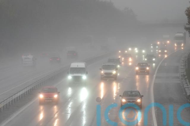
The fallout from Storm Claudia is expected to continue, with more heavy rain and flooding forecast across much of England and Wales on Saturday.
A yellow warning for rain is in place until 6am covering central and northern England, as well as the South West and Wales, with more than 80 flood warnings issued by the Environment Agency.
A severe amber warning for rain had been in place until just before midnight on Friday in central parts of the country and Wales, which had more than 60% of the month’s rainfall at one rain gauge.
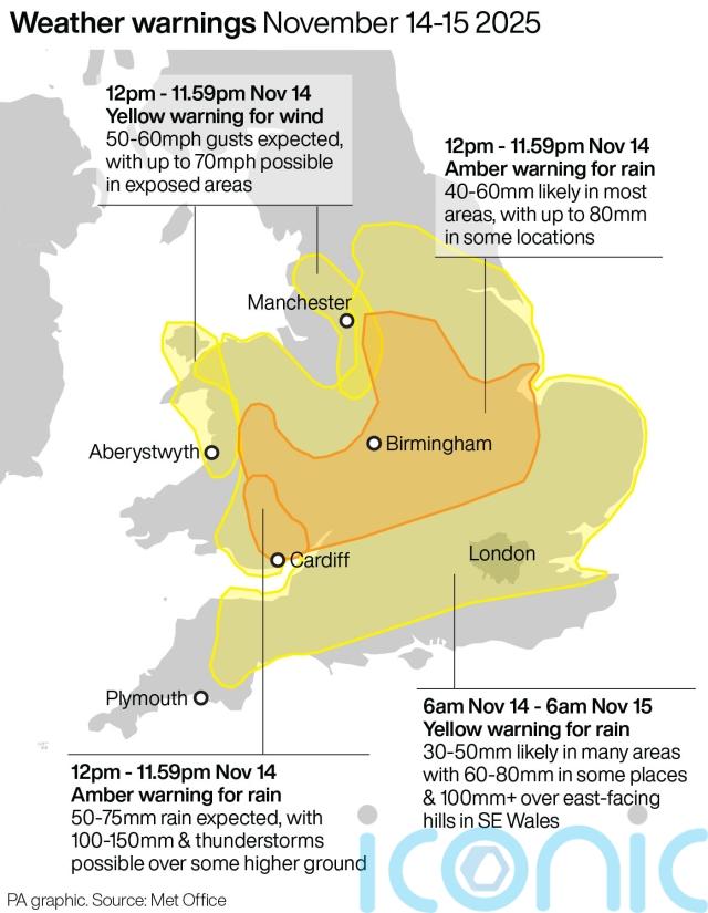
Outbreaks of rain are likely to worsen flooding, particularly in parts of eastern England and Co Down in Northern Ireland, according to the Met Office.
The Environment Agency had issued 82 flood warnings, meaning flooding is expected, by late on Friday night, with a further 194 flood alerts, meaning flooding is possible.
Downpours will quickly be replaced by a cold snap as the country braces for colder weather setting in from Sunday and into next week, which could bring snow and sleet to north-facing coasts and hills, the forecaster said.
The UK Health Security Agency (UKHSA) issued a cold weather warning for parts of the Midlands and northern England from Monday.
The worst of the rain from Storm Claudia was in southeast Wales, with 81.8mm of rain recorded at a rain gauge at Tafalog in Gwent – already 60% of the monthly November average for the region.
Areas in the north of England were flooded by the storm on Friday, with at least 17 properties affected, according to the Environment Agency.
Rail networks across England and Wales were disrupted by the weather, with heavy rain and flooding forcing a sweep of cancellations and delays.
Disruption is expected until Saturday and National Rail has advised travellers to check before they travel.
On the roads, the storm also hit rail replacement services, and roadside assistance companies reported a busy day with a high number of callouts on Friday.
What comes next after Storm Claudia?
Here's a look at the weekend forecast ⬇️ pic.twitter.com/KbG0gQLuqg
— Met Office (@metoffice) November 14, 2025
The cold weather alert is in place from 8am on Monday November 17 until 8am on Friday November 21 and covers the East Midlands, West Midlands, North East, North West and Yorkshire and The Humber.
Met Office meteorologist Honor Criswick said: “Overnight (on) Saturday and throughout the course of Sunday, we will start to see winds changing to be a bit more northerly, introducing a lot of Arctic air.
“Clouds will clear throughout the course of the day so it will allow for some sunshine, but with it, it’s going to be turning much colder.
“I think people are really going to notice a chill into Sunday and feeling cold in many areas.
“Things are starting to turn less stormy, a bit brighter, but it’s going to be feeling a lot colder and, as we head into next week, we’ll see a continuation of that.”

Subscribe or register today to discover more from DonegalLive.ie
Buy the e-paper of the Donegal Democrat, Donegal People's Press, Donegal Post and Inish Times here for instant access to Donegal's premier news titles.
Keep up with the latest news from Donegal with our daily newsletter featuring the most important stories of the day delivered to your inbox every evening at 5pm.
This publication supports the work of the Press Council of Ireland and Office of the Press Ombudsman, and our staff operate within the Code of Practice of the Press Council. You can obtain a copy of the Code, or contact the Council, at www.presscouncil.ie, Lo-call 1800 208 080 or email: info@presscouncil.ie.


