 as heartbreaking statement is issued")
RIP: Body found in search for missing man (63) as heartbreaking statement is issued
Search
10 Mar 2026
Please allow ads as they help fund our trusted local news content.
Kindly add us to your ad blocker whitelist.
If you want further access to Ireland's best local journalism, consider contributing and/or subscribing to our free daily Newsletter .
Support our mission and join our community now.
To continue reading this article, you can subscribe for as little as €0.50 per week which will also give you access to all of our premium content and archived articles!
Alternatively, you can pay €0.50 per article, capped at €1 per day.
Thank you for supporting Ireland's best local journalism!


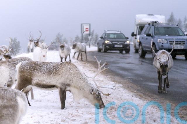
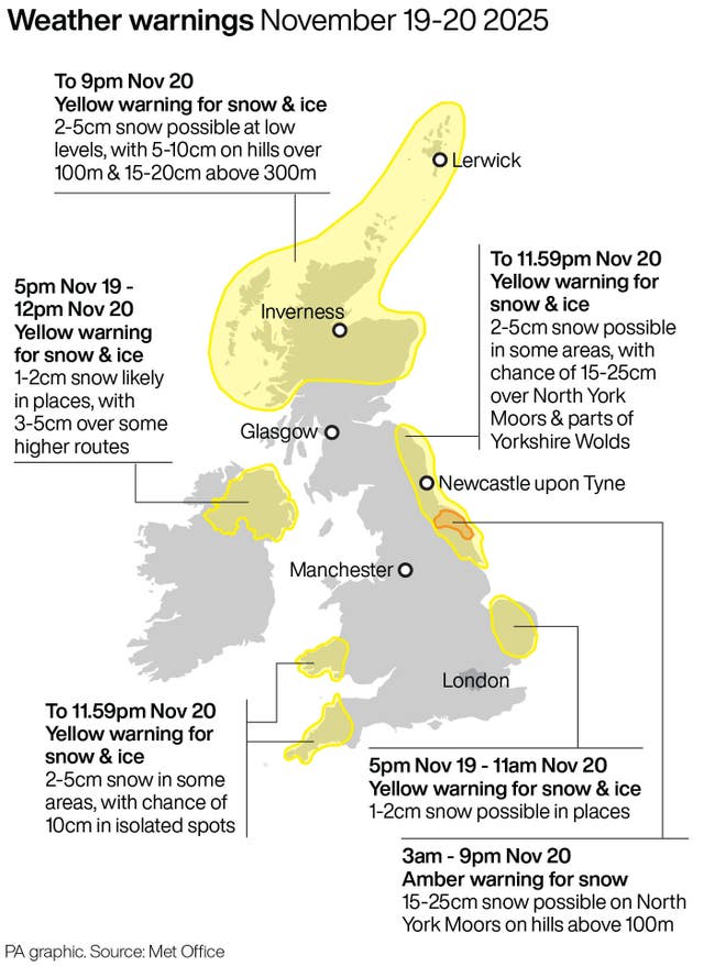
Blizzard conditions are possible in parts of north-east England where an amber warning for snow has come into force, the Met Office said.
Sleet and snow showers continued to hit UK coasts overnight into Thursday, with the worst-affected areas set to face disruption to travel and potential power cuts, the forecaster said.
As much as 25cm of snow could settle on high ground on the North York Moors and the surrounding area, where the amber warning remains in place until 9pm.
Met Office meteorologist Greg Dewhurst: “Thursday will be a sunny day for most, but there will be further sleet and snow showers for coastal stretches which will filter a little inland too. Heavy across north-east England in particular.
“The highest snowfall totals from Wednesday night through Thursday will likely be across the Sperrins, North Yorkshire Moors, Northwest Highlands, Grampians and upland Pembrokeshire.”
The national weather service said rural communities could become cut off in the amber warning area as gusty winds hit, creating “occasional blizzard conditions”, with the possibility of lightning a further hazard.
Motorists faced tricky conditions across the North East on Wednesday night, with North Yorkshire Police urging drivers to avoid the A171 near Whitby where a number of vehicles became stuck because of the snow.
Officers also closed the A169 between Whitby and Pickering amid heavy snow.
Shaun Jones, AA Expert Patrol, said: “When snow and ice hit, the roads can quickly become treacherous. Stopping distances can increase tenfold on icy surfaces, so slowing down and leaving plenty of space is absolutely vital.
“Drivers should plan ahead, stick to main routes and allow extra time for their journey.”
Wintry showers will hit East Anglia, western Wales and Cornwall overnight but persisting snow in the North East could cause “substantial disruption”, the Met Office said.
Some five yellow warnings for snow and ice are in place across the country on Thursday, with alerts for the coast of north-east England, Cornwall, Devon and western Wales in place until 11.59pm.
National Rail urged rail commuters to check their journeys before travelling during the snowy and icy weather.
It said speed restrictions may be in place for trains to run safely, which could result in cancellations, alterations and delays to services.
Cold Arctic air continues to take hold across the country, with the mercury overnight dropping to as low as -6C at Spadeadam in Cumbria.
But the coldest temperatures could still be ahead, the Met Office warned, with potential for lows of -12C in areas of lying snow in Scotland on Friday.
Temperatures will begin to rise closer to averages for this time of year at the weekend when wetter and windier weather arrives, but it will not be as “exceptionally mild” as it was earlier in November, the forecaster said.

Subscribe or register today to discover more from DonegalLive.ie
Buy the e-paper of the Donegal Democrat, Donegal People's Press, Donegal Post and Inish Times here for instant access to Donegal's premier news titles.
Keep up with the latest news from Donegal with our daily newsletter featuring the most important stories of the day delivered to your inbox every evening at 5pm.
This publication supports the work of the Press Council of Ireland and Office of the Press Ombudsman, and our staff operate within the Code of Practice of the Press Council. You can obtain a copy of the Code, or contact the Council, at www.presscouncil.ie, Lo-call 1800 208 080 or email: info@presscouncil.ie.


 killed after being struck by car as gardaí appeal for witnesses")


