Search
09 Jan 2026
Search
09 Jan 2026
Please allow ads as they help fund our trusted local news content.
Kindly add us to your ad blocker whitelist.
If you want further access to Ireland's best local journalism, consider contributing and/or subscribing to our free daily Newsletter .
Support our mission and join our community now.
To continue reading this article, you can subscribe for as little as €0.50 per week which will also give you access to all of our premium content and archived articles!
Alternatively, you can pay €0.50 per article, capped at €1 per day.
Thank you for supporting Ireland's best local journalism!


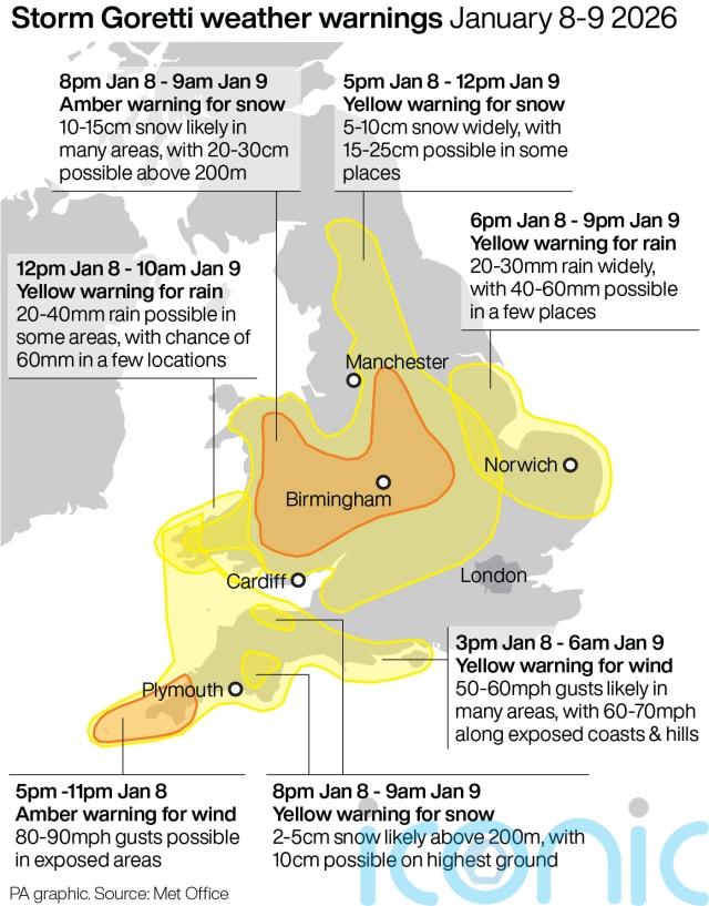
A “weather bomb” is set to bring heavy snowfall and galeforce winds to the UK as Storm Goretti hits.
The storm, named by French weather forecaster Meteo France, has been described as a “multi-hazard event” by the Met Office, with as much of 30cm of snow possible for parts of the UK and wind gusts of up to 100mph.
Weather warnings have been issued for snow, wind, rain and ice across the country ahead of likely “disruption and dangerous travelling conditions”.
Met Office chief forecaster Neil Armstrong said: “Storm Goretti will be a multi-hazard event, with the most significant impacts from snow in parts of Wales and the Midlands and the very strong winds in the far South West, though heavy rain in some parts of Wales and East Anglia also has the potential to bring disruption to many.
“Goretti will bring snow on its northern edge, this most likely over Wales and the Midlands. Here accumulations of 10-15cm are likely widely, with 20-30cm possible in some places, especially higher ground in Wales and the Peak District.
“An amber warning has been issued where the greatest risk of disruption is likely on Thursday night into Friday morning.
“This is a complex spell of severe weather and I’d advise people in the warning areas to keep up to date with the forecast and messages from local authorities.”
The BBC reports that the storm is set to bring a “weather bomb” to the UK.
Also known as explosive cyclogenesis, a weather bomb is caused when the central pressure in an area of low pressure falls rapidly.
The pressure has to fall by 24 millibars in 24 hours to qualify.
According to the BBC, Storm Goretti will see a pressure drop of 36 millibars in the 24 hours from 6pm on Wednesday to 6pm on Thursday.
The Met Office said winds during a weather bomb can be “strong enough to bring down trees and cause structural damage”.
The worst of the gusts are likely to be in the South West, including Cornwall and the Isles of Scilly, where an amber warning is in place from 4pm to 11pm and gusts could reach up to 100mph in exposed locations along the coast.
A separate yellow warning for wind has also been issued for the entire south coast, where gusts of up to 60mph are forecast.

The weather service said the “exceptional” wind speeds could be stronger than recent storms such as Ciaran in 2023 and Eunice in 2022.
Strong winds with gusts of 50-60mph could also affect south-west Wales and parts of southern England.
Meanwhile, an amber warning for snow runs from 8pm until 9am on Friday covering parts of Wales, the Midlands and South Yorkshire.
The Met Office said rain associated with the storm in these areas will turn to “heavy snow”, which may lead to some rural communities being cut off.
Around 10-15cm of snow is likely across the warning area, with up to 30cm on higher ground in Wales and the Peak District.
A yellow warning for snow is also in place from 5pm until noon on Friday for a wider part of England, from Northumberland to Wiltshire, as well as a snow and ice warning in Scotland from 10pm until noon.
In preparation for the bad weather, Network Rail and East Midlands Railway (EMR) said they would start to close down services on branch lines in the east of the region from 8pm on Thursday.
Trains will run again “as soon as possible”, Network Rail said, but that is not expected to be before 10am on Friday.
⚠️ 🌨️ Storm Goretti impacts Britain today, bringing more snow and ice.
Please continue to check before you travel with @nationalrailenq:
More information: https://t.co/Gy7l8sZdVl
➡️ https://t.co/I195vBCUIf#StormGoretti #WeatherAware pic.twitter.com/oklGYyuwqZ
— Network Rail (@networkrail) January 8, 2026
Dan Matthews, Network Rail operations director, said: “We are doing everything we can to prepare the railway for the impacts from Storm Goretti.
“In more remote parts of our network we’re anticipating the storm impact on roads will mean that our own staff will struggle to reach signal boxes and, potentially, to respond to incidents on the railway as they normally would.
“As a result, we and our colleagues in EMR have taken the difficult decision to remove late evening and early morning services.
“We’re really sorry for the impact which this will have on these communities but the safety and wellbeing of passengers and our own teams must come first. We’ll make sure websites and social media is kept up to date with the very latest information.
“We intend to run the full timetable on the Midland Main Line between London and Nottingham and Sheffield as this is controlled by central signalling and, generally, more accessible from main roads for our response teams.
“We will have extra teams out working and a snow plough working this route through the night. However, there may be delays and disruption caused by the storm here too so please plan ahead if you are travelling and continue to check your journey.”

Subscribe or register today to discover more from DonegalLive.ie
Buy the e-paper of the Donegal Democrat, Donegal People's Press, Donegal Post and Inish Times here for instant access to Donegal's premier news titles.
Keep up with the latest news from Donegal with our daily newsletter featuring the most important stories of the day delivered to your inbox every evening at 5pm.
This publication supports the work of the Press Council of Ireland and Office of the Press Ombudsman, and our staff operate within the Code of Practice of the Press Council. You can obtain a copy of the Code, or contact the Council, at www.presscouncil.ie, Lo-call 1800 208 080 or email: info@presscouncil.ie.


