
Gardaí are appealing for witnesses following a serious road traffic collision in Sligo
Search
20 Apr 2026
Please allow ads as they help fund our trusted local news content.
Kindly add us to your ad blocker whitelist.
If you want further access to Ireland's best local journalism, consider contributing and/or subscribing to our free daily Newsletter .
Support our mission and join our community now.
To continue reading this article, you can subscribe for as little as €0.50 per week which will also give you access to all of our premium content and archived articles!
Alternatively, you can pay €0.50 per article, capped at €1 per day.
Thank you for supporting Ireland's best local journalism!


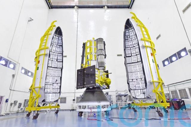
Nasa and India have teamed up to launch an Earth-mapping satellite capable of tracking the slightest shifts in land and ice.
The 1.3 billion dollar (£980 million) mission will help forecasters and first responders stay one step ahead of floods, landslides, volcanic eruptions and other disasters, according to scientists.
Rocketing to orbit from India, the satellite will survey virtually all of Earth’s terrain multiple times. Its two radars — one from the US and the other from India — will operate day and night, peering through clouds, rain and foliage to collect troves of data in extraordinary detail.
Our Earth science fleet just got… NISAR.
Shortly after launch on an @ISRO rocket, the NASA-ISRO Synthetic Aperture Radar spacecraft successfully separated from its ride to orbit.
We'd say this satellite is more than nice, it's great. 😎 Find out why at… pic.twitter.com/l5ugVYByyY
— NASA (@NASA) July 30, 2025
Microwave signals beamed down to Earth from the dual radars will bounce back up to the satellite’s super-sized antenna reflector perched at the end of a boom like a beach umbrella.
Scientists will compare the incoming and outgoing signals as the spacecraft passes over the same locations twice every 12 days, teasing out changes as small as a fraction of an inch.
It’s “a first-of-its-kind, jewel radar satellite that will change the way we study our home planet and better predict a natural disaster before it strikes,” Nasa’s science mission chief Nicky Fox said ahead of liftoff.
Ms Fox led a small Nasa delegation to India for the launch.
“Congratulations India!” minister of science and technology Jitendra Singh posted once the satellite safely reached orbit, adding that the mission “will benefit the entire world community”.
It will take a week to extend the satellite’s 30ft boom and open the 39ft-in-diameter drum-shaped reflector made of gold-plated wire mesh. Science operations should begin by the end of October.
Among the satellite’s most pressing measurements: melting glaciers and polar ice sheets; shifting groundwater supplies; motion and stress of land surfaces prompting landslides and earthquakes; and forest and wetland disruptions boosting carbon dioxide and methane emissions.
Nasa is contributing 1.2 billion dollars (£900 million) to the three-year mission – it supplied the low-frequency radar and reflector.
The Indian Space Research Organisation’s 91 million dollar (£68 million) share includes the higher-frequency radar and main satellite structure, as well as the launch from a barrier island in the Bay of Bengal. It is the biggest space collaboration between the two countries.
The satellite called Nisar — short for Nasa-Isro Synthetic Aperture Radar — will operate from a near-polar-circling orbit 464 miles high. It will join dozens of Earth observation missions already in operation by the US and India.

Subscribe or register today to discover more from DonegalLive.ie
Buy the e-paper of the Donegal Democrat, Donegal People's Press, Donegal Post and Inish Times here for instant access to Donegal's premier news titles.
Keep up with the latest news from Donegal with our daily newsletter featuring the most important stories of the day delivered to your inbox every evening at 5pm.
This publication supports the work of the Press Council of Ireland and Office of the Press Ombudsman, and our staff operate within the Code of Practice of the Press Council. You can obtain a copy of the Code, or contact the Council, at www.presscouncil.ie, Lo-call 1800 208 080 or email: info@presscouncil.ie.


