
US tool shows the future impact of the sea level rising in County Derry
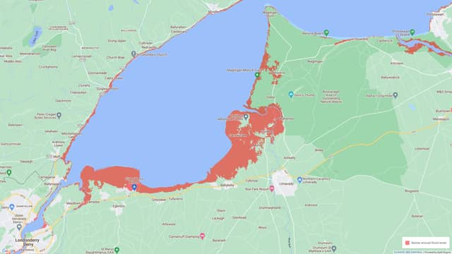

A large number of County Derry zones will be affected by the rise of the level of the sea by 2100 due to recurring flooding.
Climate Central, based in the United States, have created the Coastal Risk Screening Tool to better inform about the impact of the rise of sea levels and coastal flooding around the world. It predicts flooding in County Derry coastal areas.
Composed of an independent group of scientists and communicators, Climate Central's goal is to convey climate change science, effects, and solutions to the public and decision-makers.
First launched in 2015, the map can help identify the risk zones where more studies are necessary. It takes into account the height of the land to better predict flooding zones at risk.
“The height of the land that is determined in these maps is a combination of AI and a machine learning application that corrects it against topography or against elevation that has been calculated accurately on site,” said Peter Girard, Climate Central Vice President of Communications.
“The sea level rise projections in these maps are the ones used by the UN's IPCC. These are widely understood and widely applied sea level rise predictions.”
However, the Coastal Risk Screening Tool does not take into consideration flood protections such as barriers or dams amongst others.
Peter said that they could not include this criteria because there 'is no global data set or source of flood protection that we can apply to show the impact'.
So far they have been able to 'use global data banks and create a global dataset of essentially the height of all coastal lands in the world'.
According to the map, a large number of County Derry zones will be affected by the rise of the level of the sea by 2100 due to recurring flooding.
“Some of the areas [in County Derry] that used to be the low-lying land, have probably experienced coastal flooding already.
“The increase in sea levels around the world is relatively slow but it's accelerating. As we move particularly past the midpoint in the century past 2050, the increase comes faster and faster, and the impacts become more and more noticeable.
“I expect that many people who live close to the water in some of [County Derry] areas near the shoreline are already aware of the risk and may be aware that the risk of coastal storms is increasing,” said Peter.
At the county level, areas near Eglinton, Ballykelly, the Binevenagh Area of Outstanding Natural Beauty or Castlerock are areas at risk as soon as 2030.
“We don't know what's going to happen in the future, but you can be pretty sure that data is showing one scenario or there could be multiple ones for example if our consuming habits change drastically."
On the local scale, when planning to buy or build a house in a coastal area, the Coastal Risk Screening Tool can be a good help.
“Begin by understanding what the coastal flood risk on the property that you're looking at might be and not merely today, but in the future.
“Our maps can help you understand local risk. We always remind people that these are just screening tools. There are technologies, services and information collected at these sites, in the local communities, on the ground that can give an even more accurate picture of what the risk profile looks like.”
The Coastal Risk Screening tool is available on Climate Central website