
Drone surveys in north Louth to recommence this week

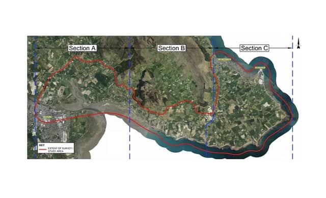

Louth County Council developing proposals for the Dundalk Bay to Carlingford Greenway project
Topographic surveys of the study area for the proposed Dundalk Bay to Carlingford Greenway project are to recommence this week, with Louth County Council providing an update to councillors of where this week's surveys are being carried out.
Cllr Antóin Watters shared the details of this week's planned surveys, after the details were shared by Louth Council, he explained, adding that updates regarding the surveys will be up on the homepage of project website at https://www.dundalkcarlingfordgreenway.ie/
Surveys are anticipated to be undertaken on the following dates at the following locations dependant of weather conditions. This will be updated if there are any changes to the proposed schedule.
- 29/01/25 – Wednesday - Section B - Rockmarshall to The Bush
- 30/01/25 – Thursday - Section C - The Bush to Carlingford
- 31/01/25 – Friday - Section C - The Bush to Carlingford
- 01/02/25 – Saturday - Bank Holiday Weekend - No Flying
- 02/02/25 – Sunday - Bank Holiday Weekend - No Flying
- 03/02/25 – Monday - Bank Holiday Weekend - No Flying
- 04/02/25 – Tuesday - Section C - The Bush to Carlingford
- 05/02/25 – Wednesday - Section C - The Bush to Carlingford
- 06/02/25 – Thursday - Section A - Dundalk to Rockmarshall
- 07/02/25 – Friday - Section A - Dundalk to Rockmarshall
The survey is being undertaken by Murphy Geospatial on behalf of Louth County Council to determine ground levels throughout the study area and are being done by drone which is a standard form of aerial topographic survey. The surveyors and their equipment are licensed to undertake these surveys by the Irish Aviation Authority, and the data obtained will be processed in compliance with GDPR requirements with regard to anonymisation of data.
The surveyors have been working from west to east from Dundalk though to Carlingford, however, they may be required to undertaken surveys out of sequence at other locations for survey control. The drones used will generally be flying at a high level although will briefly be at lower levels when taking off and landing.