
Is it a bird? No, it’s a plane! New geological survey takes flight in Limerick

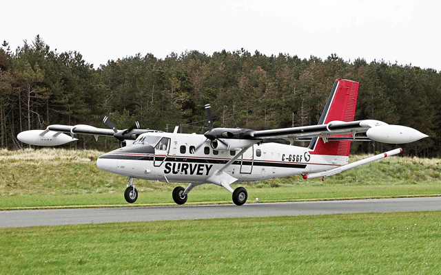

Tellus is a national mapping programme to collect geochemical and geophysical data on rocks, soil, and water across Ireland
IF YOU see a low-flying plane over parts of Limerick this summer, there is no reason to be alarmed.
There is a good chance that it is the survey airplane for the Tellus survey, carried out by Geological Survey Ireland, a division of the Department of the Environment, Climate and Communications.
The survey airplane is a white, twin propeller plane, easily identifiable by its red tail and black stripe. The word ‘SURVEY’ and the registration number C-GSGF are written across both sides of the plane.
The plane will be based at Shannon Airport and will fly over Cork, Kerry, and parts of Limerick from June until the end of autumn, weather permitting. It will be flying at 60 metres over rural areas and 240 metres over urban areas.
Tellus, named after the Roman goddess of the earth, is a national mapping programme to collect geochemical and geophysical data on rocks, soil, and water across Ireland. It began 13 years ago and aims to have 100% of Ireland mapped by the end of 2025.
“With over 80% of the island already covered, our team is looking forward to tackling the remaining portion of this substantial project,” explained Dr James Hodgson, Tellus project manager at Geological Survey Ireland.
“The airborne data already produced has helped us to improve our geological maps, enhance radon risk mapping and facilitated new research on environmental pollution, agricultural productivity, and the study of peatlands,” Dr Hodgson added.
To gather this data, scientific equipment is fitted to a plane which flies in a grid pattern. The aircraft carries a range of instruments on board for navigation purposes and to measure geophysical properties of the ground.
Due to the low-flying altitude of the survey aircraft, anyone concerned about sensitive livestock is encouraged to contact the Tellus Freephone Information Line on 1800 45 55 65 to get information on upcoming flight plans.
Data collected throughout the Tellus project is freely available on the Tellus website.