
WARNING: Met Éireann's five-day forecast predicts some disastrous weather on the horizon

Take note!
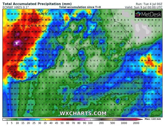
THURSDAY: It will be a rather wet and windy day with widespread falls of rain and drizzle, heaviest and most persistent across Atlantic counties with spot flooding. Low cloud and mist in parts too. Highest temperatures of 15 to 19 degrees Celsius in fresh to strong southerly winds.
OUTLOOK: Unsettled and warmer, but with some uncertainty yet.
THURSDAY NIGHT: Wet and rather windy overnight too with some further blustery spells of rain. Mild and humid with lowest temperatures of 13 to 16 degrees Celsius.
FRIDAY: Currently the western half of the country is in line for some potentially intense heavy falls of rain, while staying drier further east. Warm and humid with highest temperatures of 18 to 23 degrees Celsius, in mostly fresh southeast winds.
SATURDAY: Currently blustery spells of thundery rain and fresh southeast winds will persist for much of the day but with sunshine and moderating westerly breezes following later. Highest temperatures of 18 to 22 degrees Celsius.
SUNDAY: Widespread heavy thundery showers with spot flooding, especially later in the day. Highest temperatures of 17 to 22 degree Celsius in light to moderate southerly breezes.