
NEW: Yellow thunderstorm warning issued for Laois


Met Éireann has told Laois locals to expect lightening damage
Met Éireann has issued a Status Yellow thunderstorm warning for county Laois.
This warning is in place from 7pm this evening to 7am on Tuesday morning.
There is a rain and thunderstorm warning for four counties in the west and south, and a separate thunderstorm warning for a further ten counties mostly in the east.
The rain and thunderstorm warning covers counties Clare, Kerry, Limerick and Galway.
The Status Yellow thunderstorm warning has also been issued for Carlow, Dublin, Kildare, Kilkenny, Laois, Louth, Meath, Offaly, Westmeath and Wicklow.
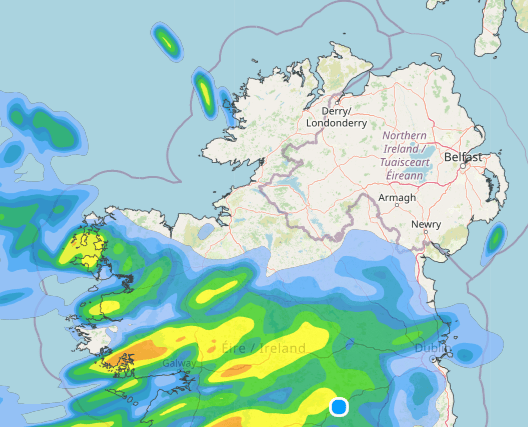
Pictured: Met Éireann map forecasting rain on Monday July 14.
Here is the latest forecast from Met Éireann for this week, Monday July 14 and onwards;
Overview: Mixed and changeable overall through the coming week. Cooler and fresher than recently, but turning a little milder around mid-week.
Tuesday night: Mainly dry with clear spells but thickening cloud in the southwest will bring outbreaks of rain near the southwest coast by morning. Areas of mist and fog will form also, as winds fall light and variable. Lowest temperatures of 8 to 13 degrees.
Wednesday: Any mist and fog will clear during the morning and it will be bright for a time in the north and east with some hazy sunshine, but cloud with outbreaks of rain and drizzle in the southwest will gradually extend northeastwards over the country through the day. Highest temperatures of 17 to 21 degrees with light to moderate south to southeast winds. Cloudy with outbreaks of rain on Wednesday night, turning heavy at times. Mild with temperatures not falling below 13 to 17 degrees, in light to moderate southerly winds.
Thursday: Mostly cloudy with outbreaks for rain breaking up into showers and sunny spells during the afternoon and evening. Some of the showers will be heavy with a chance of isolated thunderstorms. Highest temperatures of 18 to 23 degrees with light to moderate south to southwest winds.
Friday: Current indications suggest variable cloud amounts with some sunshine and scattered showers. Highest temperatures of 17 to 21 degrees in light southwest or variable breezes.
Next Weekend: Unsettled overall with low pressure dominating bringing showers or longer spells of rain at times. Temperatures around average.