
Storm Bram to be an 'impactful event' warns Met Éireann

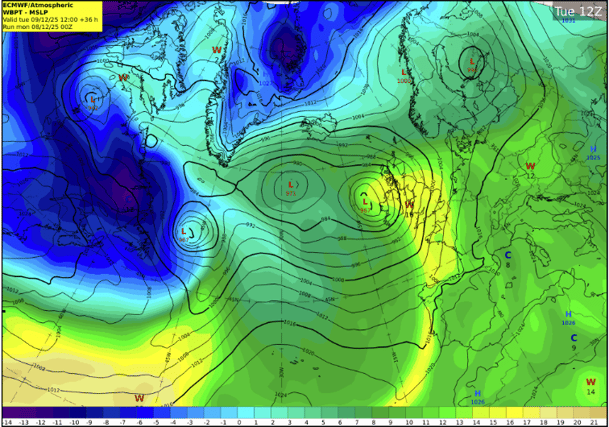

Met Éireann issues Storm Bram Status Orange and Status Yellow weather warnings Ireland
Met Éireann has warned Storm Bram will bring strong winds and heavy rain that will be an 'impactful' weather event in Laois and across Ireland on Monday night and during Tuesday.
The weather forecaster says it is closely monitoring the developing Atlantic system, which it warns is expected to bring strong winds, high coastal water levels, and heavy rainfall to Ireland from late Monday, December 8, through to Tuesday, December 9.
Met Éireann also warns that the rain is likely to result in surface and river flooding on Tuesday and possibly during following days as Storm Bram hits after a week of persistent rain that has saturated soil and left many rivers near full.
Met Éireann says it is clear that it will bring "compound impacts" to several counties during the daytime on Tuesday, December 9, due to the mix of strong winds, rain and high tides.
The forecaster adds that the storm has been named due to the effect of those strong winds on coastal areas at times of high tide, and the heavy rain falling on already saturated ground, all of which increase flood risk.
Meteorologist Matthew Martin outlined what to expect.
"Given its evolving nature, we have issued a yellow wind warning for the entire country, followed by a set of orange wind warnings for southern and western coastal counties, as they are most vulnerable to the compound effects of the wind at high tide. We have also issued a yellow rainfall warning for Carlow, Kilkenny, Wexford, Cork, Kerry, Tipperary and Waterford, but we encourage everyone to check in regularly with Met Éireann’s forecasts and warnings, as the situation is likely to evolve with certainty in the system track and timings increase," he said.
Mr Martin warned that flooding and high tides are on the cards.
“Flooding impacts are expected as the rain will fall on already saturated ground and many rivers are currently approaching bank full conditions. We are in a period of high astronomical tides, which will coincide with the strong, potentially onshore winds, so there is high risk of coastal flooding. We echo the well-known advice of the Irish Coast Guard: 'Stay Back, Stay High, Stay Dry'.
"The high tides will prevent the rivers from discharging to the sea, significantly increasing the risk of upstream flooding along low-lying areas. People should refer to the guidance of their local authorities and emergency responders in their area,” he warned.
WARNINGS AND IMPACTS
Met Éireann says the intensity of the winds and their impacts will depend on the interaction of the low with the jet stream, but to raise awareness of the potential impacts it has issued the following warnings:
A Status Yellow rain warning across southern counties, with heavy rain expected to fall on already saturated ground and with many rivers in southern regions approaching bank full conditions after a week of steady rain.
Expected impacts, throughout Tuesday (even if the rain warning will expire on Tuesday morning) are:
- Surface and river flooding, through the whole day Tuesday and possibly Wednesday, even if the rain warning will expire on Tuesday morning, as the rivers may take time to respond. Coinciding high tides will prevent river water from discharging to the sea, causing water to back up and significantly increasing the risk of upstream flooding along low-lying areas, especially across rivers in Cork, south Kerry, south Tipperary and Waterford.
- Difficult travel conditions
- Potential disruption to outdoor events.
A Status Yellow wind warning for Ireland all day Tuesday, followed by an Orange wind warnings for southern and western counties due to very strong to gale force southerly winds expected, strongest along the coast.
Expected impacts include:
- Very difficult travel conditions: Surface water, reduced visibility, and strong winds may make driving hazardous and could lead to delays on roads, rail, ferry and/or air services. Allow extra time and take caution on exposed routes.
- Flooding in low-lying coastal areas: The combination of the southerly, onshore winds with very high astronomical tides and wave action will heighten the risk of coastal flooding. Surge levels will rise to 0.8m in some locations and significant waves are forecast.
- Coastal flooding is likely, particularly during high tide times and in exposed low-lying areas. High tide on southern and western coasts is early Tuesday morning (7-9am), whilst time of high tide is close to 2pm on eastern coasts. “Stay Back, Stay High, Stay Dry”.
- Wave overtopping: Large waves may breach sea walls or coastal barriers, posing risks to people near shorelines and potentially impacting coastal infrastructure in exposed locations.
- Fallen trees, debris and loose objects displaced: Strong winds could lift unsecured items, increasing the risk of damage or hazards on roads and in public spaces.
- Outdoor events impacted: Weather conditions may lead to delays, cancellations, or the need for additional safety measures for outdoor activities.
The warnings may be updated as new model runs are analysed and certainty increases. For the latest warnings details, please check Warnings & Advisories – Met Éireann – The Irish Meteorological Service
METEOROLOGICAL SITUATION
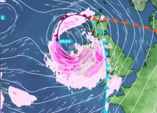
Met Éireann say the deepening Atlantic depression will track close to Ireland on Monday night and Tuesday.
It says southerly winds ahead of the system will strengthen on Monday night, with periods of severe wind gusts possible, especially near exposed Atlantic coasts. The strong winds will continue through Tuesday, veering southwest to west in direction during the day. Heavy rainfall late Monday into Tuesday morning will fall over ground that is already water-logged, increasing runoff and river response times.
Confidence remains moderate regarding the exact track and intensity of the system; small shifts will influence the severity of impacts. A slight shift in the system’s path could influence peak wind gusts, timing of strongest winds, and the extent of coastal impacts. Met Éireann will continue to monitor the system closely and update warnings as required.