
Gardaí are appealing for witnesses following a serious road traffic collision in Sligo
Search
21 Apr 2026
Please allow ads as they help fund our trusted local news content.
Kindly add us to your ad blocker whitelist.
If you want further access to Ireland's best local journalism, consider contributing and/or subscribing to our free daily Newsletter .
Support our mission and join our community now.
To continue reading this article, you can subscribe for as little as €0.50 per week which will also give you access to all of our premium content and archived articles!
Alternatively, you can pay €0.50 per article, capped at €1 per day.
Thank you for supporting Ireland's best local journalism!


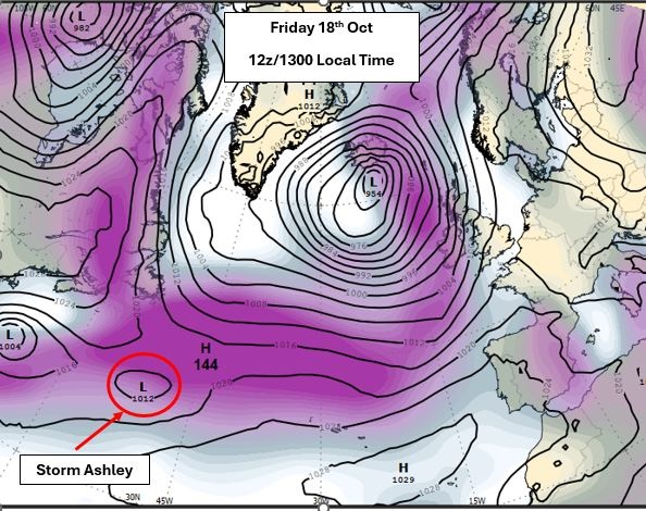
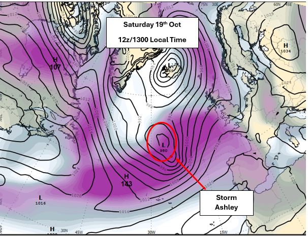
Met Éireann has put Ireland on alert for a double hit of stormy weather as Storm Ashley hits Ireland.
A commentary from the forecaster says Storm Ashley is a low-pressure system originating in the western North Atlantic, on the southern side of the Jet Stream. It is expected to travel quickly sweep eastwards over the Atlantic this weekend and undergo rapid deepening later on Saturday. The system will become a storm depression as it swings up to the west and northwest of Ireland on Saturday night and Sunday
Met Éireann’s meteorologist Liz Walsh expects a two waves of bad weather from Storm Ashley.
“Storm Ashley will bring strong southerly winds overnight on Saturday night and early Sunday with a second wave of even stronger south-westerly winds, accompanied by damaging gusts across the country, from mid-morning on Sunday, right though the afternoon and into the evening in some parts. MORE BELOW CHART.
“We are currently in a period of exceptionally high spring tides, and this, tied in with the strong winds and high waves, will substantially increase the risk of coastal flooding, especially along Atlantic coasts,” she said.
Met Éireann has issued an Orange Wind Warning for some western counties and a Yellow Wind Warning for Ireland, for Sunday, but the warnings are likely to be updated as more information as the forecaster's high-resolution models comes in and is analysed by the forecaster's meteorologists. MORE BELOW CHART.
KEY INFORMATION – Met Éireann SUMMARY OF Storm Ashley IMPACTS

Met Éireann says warnings are likely to be updated through the weekend so it adises the public to keep in touch with Met Éireann’s social media channels, www.met.ie and the Met Éireann app.
It says the timing and location of extreme weather occurrences can significantly affect their impact. It’s important to note that in any individual weather event, not every location within a warning area may experience the same degree of weather or impacts.
When severe weather is expected, weather and impacts at lower levels are also likely to be experienced. The type and level of impacts can be strongly affected by previous weather conditions. When issuing a warning, Met Éireann says it takes into consideration the forecasted conditions and thresholds, as well as previous weather conditions that may increase the level of impact expected for particular areas.
HOW TO STAY SAFE IN EXTREME WEATHER
You can monitor www.powercheck.ie in regards to power restoration times
“Be Winter Ready”: Follow recommendations before, during and after the event on gov.ie – Be Winter Ready (www.gov.ie)

Subscribe or register today to discover more from DonegalLive.ie
Buy the e-paper of the Donegal Democrat, Donegal People's Press, Donegal Post and Inish Times here for instant access to Donegal's premier news titles.
Keep up with the latest news from Donegal with our daily newsletter featuring the most important stories of the day delivered to your inbox every evening at 5pm.
This publication supports the work of the Press Council of Ireland and Office of the Press Ombudsman, and our staff operate within the Code of Practice of the Press Council. You can obtain a copy of the Code, or contact the Council, at www.presscouncil.ie, Lo-call 1800 208 080 or email: info@presscouncil.ie.


