
The woman was conveyed to University Hospital Limerick for treatment of serious injuries. She was pronounced deceased yesterday evening.
Search
02 Apr 2026
Please allow ads as they help fund our trusted local news content.
Kindly add us to your ad blocker whitelist.
If you want further access to Ireland's best local journalism, consider contributing and/or subscribing to our free daily Newsletter .
Support our mission and join our community now.
To continue reading this article, you can subscribe for as little as €0.50 per week which will also give you access to all of our premium content and archived articles!
Alternatively, you can pay €0.50 per article, capped at €1 per day.
Thank you for supporting Ireland's best local journalism!

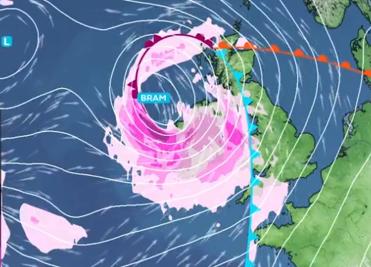
Storm Bram developing in the Atlantic to combine with high tides.

Met Éireann has warned Storm Bram will bring strong winds and heavy rain that will be an 'impactful' weather event in Laois and across Ireland on Monday night and during Tuesday.
The weather forecaster says it is closely monitoring the developing Atlantic system, which it warns is expected to bring strong winds, high coastal water levels, and heavy rainfall to Ireland from late Monday, December 8, through to Tuesday, December 9.
Met Éireann also warns that the rain is likely to result in surface and river flooding on Tuesday and possibly during following days as Storm Bram hits after a week of persistent rain that has saturated soil and left many rivers near full.
Met Éireann says it is clear that it will bring "compound impacts" to several counties during the daytime on Tuesday, December 9, due to the mix of strong winds, rain and high tides.
The forecaster adds that the storm has been named due to the effect of those strong winds on coastal areas at times of high tide, and the heavy rain falling on already saturated ground, all of which increase flood risk.
Meteorologist Matthew Martin outlined what to expect.
“It’s looking increasingly likely that Ireland will experience some very inclement weather from Monday night and through Tuesday. A low-pressure system in the Atlantic is going to deepen fairly rapidly as it approaches the southwest coast on Monday night. Initially there will be a spell of heavy rain before a swathe of very strong winds develop. There remains some uncertainty in the track and intensity of the system, but it looks likely that this will be an impactful event in some areas, especially in coastal areas of the south, west and northwest. MORE BELOW PHOTO.
"Given its evolving nature, we have issued a yellow wind warning for the entire country, followed by a set of orange wind warnings for southern and western coastal counties, as they are most vulnerable to the compound effects of the wind at high tide. We have also issued a yellow rainfall warning for Carlow, Kilkenny, Wexford, Cork, Kerry, Tipperary and Waterford, but we encourage everyone to check in regularly with Met Éireann’s forecasts and warnings, as the situation is likely to evolve with certainty in the system track and timings increase," he said.
Mr Martin warned that flooding and high tides are on the cards.
“Flooding impacts are expected as the rain will fall on already saturated ground and many rivers are currently approaching bank full conditions. We are in a period of high astronomical tides, which will coincide with the strong, potentially onshore winds, so there is high risk of coastal flooding. We echo the well-known advice of the Irish Coast Guard: 'Stay Back, Stay High, Stay Dry'.
"The high tides will prevent the rivers from discharging to the sea, significantly increasing the risk of upstream flooding along low-lying areas. People should refer to the guidance of their local authorities and emergency responders in their area,” he warned.
WARNINGS AND IMPACTS
Met Éireann says the intensity of the winds and their impacts will depend on the interaction of the low with the jet stream, but to raise awareness of the potential impacts it has issued the following warnings:
A Status Yellow rain warning across southern counties, with heavy rain expected to fall on already saturated ground and with many rivers in southern regions approaching bank full conditions after a week of steady rain.
Expected impacts, throughout Tuesday (even if the rain warning will expire on Tuesday morning) are:
A Status Yellow wind warning for Ireland all day Tuesday, followed by an Orange wind warnings for southern and western counties due to very strong to gale force southerly winds expected, strongest along the coast.
Expected impacts include:
The warnings may be updated as new model runs are analysed and certainty increases. For the latest warnings details, please check Warnings & Advisories – Met Éireann – The Irish Meteorological Service
METEOROLOGICAL SITUATION
Met Éireann say the deepening Atlantic depression will track close to Ireland on Monday night and Tuesday.
It says southerly winds ahead of the system will strengthen on Monday night, with periods of severe wind gusts possible, especially near exposed Atlantic coasts. The strong winds will continue through Tuesday, veering southwest to west in direction during the day. Heavy rainfall late Monday into Tuesday morning will fall over ground that is already water-logged, increasing runoff and river response times.
Confidence remains moderate regarding the exact track and intensity of the system; small shifts will influence the severity of impacts. A slight shift in the system’s path could influence peak wind gusts, timing of strongest winds, and the extent of coastal impacts. Met Éireann will continue to monitor the system closely and update warnings as required.

Subscribe or register today to discover more from DonegalLive.ie
Buy the e-paper of the Donegal Democrat, Donegal People's Press, Donegal Post and Inish Times here for instant access to Donegal's premier news titles.
Keep up with the latest news from Donegal with our daily newsletter featuring the most important stories of the day delivered to your inbox every evening at 5pm.
This publication supports the work of the Press Council of Ireland and Office of the Press Ombudsman, and our staff operate within the Code of Practice of the Press Council. You can obtain a copy of the Code, or contact the Council, at www.presscouncil.ie, Lo-call 1800 208 080 or email: info@presscouncil.ie.


