Search
07 Mar 2026
Search
07 Mar 2026
Please allow ads as they help fund our trusted local news content.
Kindly add us to your ad blocker whitelist.
If you want further access to Ireland's best local journalism, consider contributing and/or subscribing to our free daily Newsletter .
Support our mission and join our community now.
To continue reading this article, you can subscribe for as little as €0.50 per week which will also give you access to all of our premium content and archived articles!
Alternatively, you can pay €0.50 per article, capped at €1 per day.
Thank you for supporting Ireland's best local journalism!


Storm Goretti continues to batter the UK, with tens of thousands of Britons across the country facing widespread power cuts, travel disruption and school closures.
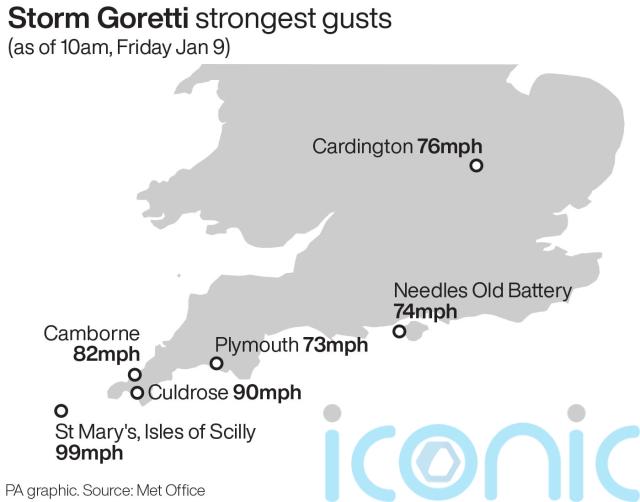
It comes after the wild, wintry weather brought 99mph winds while a rare red warning was issued by the Met Office for “dangerous, stormy” winds in the South West.
More than 44,000 properties were without power in the South West at 11am on Friday, according to the National Grid’s website, while about 14,000 had no power in the West Midlands, more than 700 had no power in the East Midlands and more than 500 were without power in Wales.
As of 8am, 147,983 properties had been restored across the South West, Midlands and South Wales.
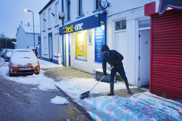
The Met Office said on Friday morning that Storm Goretti “continues to cause problems” as a mixture of rain, sleet and snow batters some areas.
Meteorologist Alex Deakin said the storm will continue to clear throughout the day, but many still face a “wet, cold, miserable day”.
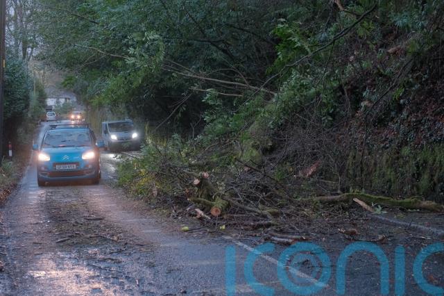
Cornwall Council advised residents to avoid travelling on Friday morning, saying: “A large number of roads are still closed due to fallen trees, downed power lines and debris.
“Our teams are working around the clock to clear them and we ask that you give crews the space they need to carry out urgent repairs safely.”
At least 69 flights scheduled to operate to or from Heathrow airport have been cancelled, likely disrupting more than 9,000 passengers.
The majority of the cancellations are short-haul flights by British Airways.
Storm Goretti has now cleared to the east. The storm brought a gust of 99mph at St Mary's in the Isles of Scilly, and 16cm of snow at Lake Vyrnwy in Wales pic.twitter.com/r83TfoeSEA
— Met Office (@metoffice) January 9, 2026
In a statement issued just after 6am, East Midlands Airport said its runway had reopened after being closed overnight due to heavy snow on the runway.
Passengers were warned delays may linger throughout the day.
Birmingham Airport said at 7.15am that its runway had reopened on a “reduced basis” and teams were working to get passengers moving as efficiently as possible.
Winds of 99mph were recorded at St Mary’s Airport on the Isles of Scilly on Thursday, which is a new record for the site, the Met Office said.
Rail services across England, Wales and Scotland may be affected until the end of the day on Friday due to the weather, National Rail said.
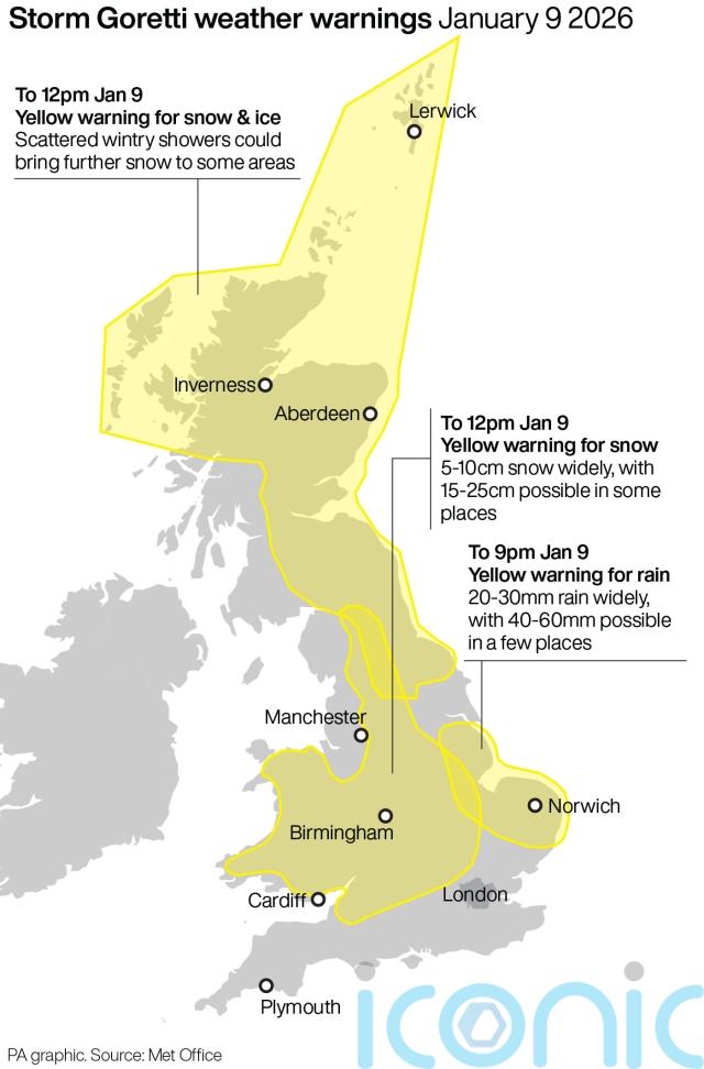
The storm, named by French weather forecaster Meteo France, has been described as a “multi-hazard event” by the Met Office, with as much as 30cm of snow possible in parts of the UK.
Yellow weather warnings for snow and ice have been extended into Saturday for large parts of Scotland, England and Northern Ireland.
A yellow warning for snow and ice comes into force from midday on Friday until 3pm on Saturday, with further snowfall possible across parts of northern England and much of Scotland, while a widespread risk of ice is expected to cause disruption.
A separate yellow warning for ice will cover large parts of England and Wales from midday on Friday until midday on Saturday as partially thawed snow refreezes, accompanied by wintry showers and freezing fog.
In Northern Ireland, a yellow warning for snow and ice will come into force from 5pm on Friday and run until 11am on Saturday, with the Met Office warning of icy patches and some hill snow.
Meanwhile, skies across the West Midlands turned pink on Thursday evening with dramatic pictures capturing the unusual sight.
It was believed that lights from a football stadium was exacerbating the phenomenon.
Grahame Madge, Met Office spokesman, said: “The blue wavelengths of light are more easily scattered by snow or water droplets allowing the longer wavelengths – such as red and orange – to get through. This can have the effect of turning colours more pink or orange.”
Dozens of schools across the Midlands and Wales announced they would be closed on Friday where the amber weather warning was issued.
More than 250 schools were expected to remain closed in Scotland, including more than 150 in Aberdeenshire, dozens in the Highlands and Aberdeen, plus a number in Moray.
The red warning, which was in place until 11pm on Thursday, warned of damage to buildings and homes, very large waves, flying debris resulting in danger to life, power cuts and public transport cancellations.
The Met Office’s website says amber weather warnings are issued when there is an increased likelihood of impacts from severe weather, including the possibility of travel delays, road and rail closures, power cuts and the potential risk to life and property.
Yellow warnings are issued for a range of weather situations, including when it is likely that the weather will cause some low level impacts, including some disruption to travel in a few places, or when the weather could bring much more severe impacts to the majority of people but the certainty of those impacts occurring is much lower, according to the Met Office.

Subscribe or register today to discover more from DonegalLive.ie
Buy the e-paper of the Donegal Democrat, Donegal People's Press, Donegal Post and Inish Times here for instant access to Donegal's premier news titles.
Keep up with the latest news from Donegal with our daily newsletter featuring the most important stories of the day delivered to your inbox every evening at 5pm.
This publication supports the work of the Press Council of Ireland and Office of the Press Ombudsman, and our staff operate within the Code of Practice of the Press Council. You can obtain a copy of the Code, or contact the Council, at www.presscouncil.ie, Lo-call 1800 208 080 or email: info@presscouncil.ie.


