
Met Eireann weekend weather as forecast updated after storm threat
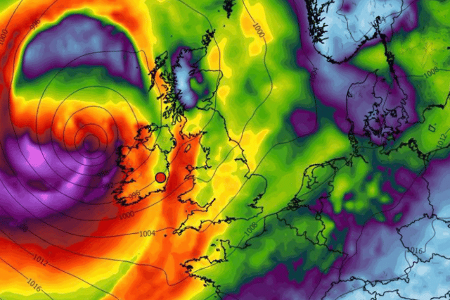

Weather experts are warning we could see the first storm of the year hit
Met Eireann is still keep shtum despite warnings from other weather experts that we could see remnants of a storm into the start of next week.
Friday will be a showery type of day with only the south staying dry. Cloud will break later in the morning with sunny spells appearing in between the drops as temperatures hit 18C.
The dial will drop to as low as 8C overnight with patches of mist hitting the west along with some light winds as isolated showers hit from time to time.
Carlow Weather and Weather Alerts Ireland, both of whom have been known for catching previous major storms in Ireland early on, were both in agreement that something big could hit next Tuesday or Wednesday.
Carlow Weather’s Alan O’Reilly alerted his followers saying: “Still some uncertainty around this weekend and especially Saturday.
“At present the risk of rain for Croke Park is low Saturday. The weather models also show a risk of a storm next Tuesday into Wednesday.
“Nothing too severe but one to keep an eye on and could be our first real blast of wind in a while.”
While Weather Alerts Ireland added: “A risk of a storm moving towards Ireland next Tuesday. The UK and ECMWF models are both forecasting a low pressure system approaching Ireland.
“This has been forecast on different models on different days too. Still plenty of time for change so I will be watching over the coming days.”
This is how the weekend weather and into next week is looking according to Met Eireann:
Overview: “Changeable and often unsettled with low pressure continuing to dominate.”
Saturday: “Tomorrow morning will start mostly dry with sunny spells, isolated showers and patches of mist. Cloud will increase through the morning and rain or drizzle will develop in the southwest. This will extend northeastwards to most areas through the day. There'll be mist and hill fog too. Highest temperatures of 15 to 19 degrees with light to moderate south to southwest winds turning south to southeast.”
Sunday: “It will be a breezy day with fresh and gusty southerly winds. Mostly cloudy with outbreaks of rain moving eastwards across the country. Highest temperatures of 18 to 22 degrees.
Monday: “Monday morning will be dry with sunny spells but it'll become cloudy, wet and breezy for the afternoon as a spell of rain moves in from the west. Top temperatures of 15 to 18 degrees with moderate to fresh and gusty southwesterly winds.”
Tuesday: “There is uncertainty in the details but there is potential for a spell of wet and breezy weather during Tuesday and Tuesday night. Highest temperatures on Tuesday of 13 to 19 degrees, warmest in the south.”