
ALERT: Ireland heading back into 'stormy weather' next week and it doesn't look good!
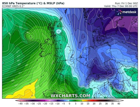

"It looks like the cold might hang on for a few more days with rain staying south on Sunday keeping cooler air in place until Tuesday evening when rain is likely and a risk of heavy rain Wednesday," forecaster Alan O'Reilly has said.
He added: "Also a risk of strong winds Wednesday into Thursday as we head back into stormy weather for a while at least. A chance the cold could make a return but wait and see for now.
"We look likely to head back into stormy weather coming across the Atlantic next week. Hoping they miss us but latest models brings one very close next Thursday."
Met Éireann's five-day forecast is below:
FRIDAY: Very cold with frost and ice slow to clear. Bright with spells of sunshine and scattered showers, mainly in the west, north and midlands, although the odd shower will still affect eastern coasts. Some showers will fall as hail and sleet. Highest temperatures of 2 to 6 degrees in light variable breezes.
FRIDAY NIGHT: It will be cold with well scattered showers over the western half of the country, possibly falling as sleet or snow at times. Staying drier further east. Turning foggy in places with freezing fog developing too. Widespread frost and icy stretches once again with lowest temperatures of 0 to -4 degrees.
SATURDAY: A frosty, icy and foggy start for many, with ice and fog patches lingering through the day in some areas. Elsewhere will be clear with scattered showers and sunny spells. Showers will be most frequent in the west and northwest and some will be heavy with hail, sleet and snow possible. Highest temperatures of just 1 to 5 degrees, a little milder near coasts, in light west to southwest winds.
OUTLOOK: Very cold with frost, ice and some wintry precipitation. Less cold by next week.
SATURDAY NIGHT: Cold overnight, with scattered outbreaks of rain and drizzle moving in off the Atlantic, possibly turning wintry over higher ground. Lowest temperatures of -3 to +2 degrees, with light variable breezes.
SUNDAY: Sunday will likely be a mostly dry day with showers lingering near coasts, along with low cloud or mist struggling to clear through the day. Highest temperatures of 1 to 5 degrees, with light northeasterly breezes.
MONDAY: Current indications suggest that wet and windy weather will spread over the south and east of the country early on Monday, with the possibility of scattered falls of sleet. Coldest in the north with milder weather possible in the south.
FURTHER OUTLOOK: Considerable uncertainty in the further outlook, with a signal for a return to a more Atlantic regime.