
ALERT: 'Nasty' system part of Irish weather forecast for coming week

Met Éireann's five-day Irish weather forecast is also in...
There's uncertainty on weather models for this coming week but a risk of some very heavy rain on Tuesday with "nasty thunderstorms possible" says forecaster Alan O'Reilly.
He added: "High pressure comes close to Ireland after that but seems to get pushed away quickly.
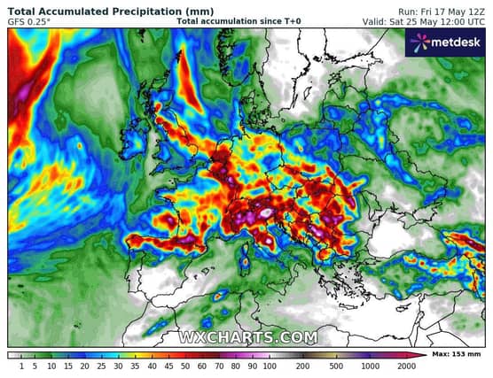
"Total seven day rainfall forecast for many parts of Europe looks serious, I wouldn’t be surprised to see some serious thunderstorms reports from parts of Europe next week."
Met Éireann's four-day forecast is below:
Overview: Warm and humid at first with the potential for thunderstorm activity; Turning cooler and less humid from midweek.
Sunday night: Any showers or thunderstorms will die away early on Sunday night to leave a dry night under mostly clear skies. Areas of mist and fog will form in the near calm conditions. Lowest temperatures of 8 to 11 degrees.
Monday: Any mist and fog will soon clear on Monday morning with long spells of sunshine developing. Showers will break out in some areas during the afternoon and evening with the possibility of thunderstorms.
Warm with highest temperatures of 18 to 23 degrees in light southeast or variable winds.
A few showers will persist through Monday night but most places will be dry with long clear spells developing. Areas of mist and fog will form in the light easterly or variable breezes. Lowest temperatures of 9 to 12 degrees.
Tuesday: Showers will develop on Tuesday morning, merging to longer spells of rain during the afternoon and evening, with potentially heavy and thundery downpours.
Localised flooding is possible. Winds will be light and variable. Highest temperatures of 16 to 19 degrees.
Wednesday: A mix of sunny spells and showers, some heavy. Noticeably cooler than the preceding days with highest temperatures of 14 to 18 degrees in light to moderate west to northwest winds.
Further Outlook: Changeable with temperatures trending closer to average.